IMAGES TAKEN NEAR TO
Donegall Avenue, BELFAST, BT12 6LY
Introduction
This page details the photographs taken nearby to Donegall Avenue, BT12 6LY by members of the Geograph project.
The Geograph project started in 2005 with the aim of publishing, organising and preserving representative images for every square kilometre of Great Britain, Ireland and the Isle of Man.

There are currently over 7.5m images from over14,400 individuals and you can help contribute to the project by visiting https://www.geograph.org.uk
Image Map
Images are licensed for reuse under creativecommons.org/licenses/by-sa/2.0
Notes
- Clicking on the map will re-center to the selected point.
- The higher the marker number, the further away the image location is from the centre of the postcode.
Image Listing (217 Images Found)
Images are licensed for reuse under creativecommons.org/licenses/by-sa/2.0
Image
Details
Distance
1
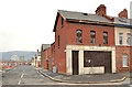
Disused shop, Donegall Avenue, Belfast - 2014 (1)
A disused shop on the northern corner of Kitchener Drive (Kitchener Street on the Google map). Continue to Image
Image: © Albert Bridge
Taken: 30 Jan 2014
0.01 miles
2
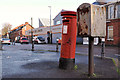
Pillar box and drop box, Belfast
Drop box and GR pillar box in Donegall Avenue, at the corner of Frenchpark Street.
Image: © Albert Bridge
Taken: 10 Nov 2011
0.02 miles
3
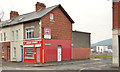
Disused shop, Donegall Avenue, Belfast - 2014 (2)
A disused shop on the southern corner of Kitchener Drive (Kitchener Street on the Google map). This one Image is on the right.
Image: © Albert Bridge
Taken: 30 Jan 2014
0.02 miles
4
Kitchener Street, Belfast (5)
Kitchener Street Image (left) at the corner of Frenchpark Street. Image shows the same corner from a different angle.
Image: © Albert Bridge
Taken: 23 May 2012
0.03 miles
5
Kitchener Street, Belfast (4)
The entire length of Kitchener Street, seen from Frenchpark Street, looking towards Broadway.
Image: © Albert Bridge
Taken: 23 May 2012
0.04 miles
6
Frenchpark Street, Belfast (3)
Frenchpark Street, looking towards Glenmachan Street, with Kitchener Street Image on the right. This one Image shows the same corner from a different angle.
Image: © Albert Bridge
Taken: 23 May 2012
0.04 miles
7
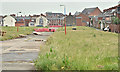
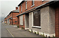
Kitchener Street, Belfast (June 2016)
The Frenchpark Street end of Kitchener Street – grassed and awaiting redevelopment.
Image: © Albert Bridge
Taken: 7 Jun 2016
0.04 miles
8
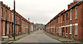
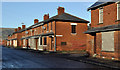
Kitchener Street, Belfast (1)
A street, off Frenchpark Street Image, which seems to have been built at the end of the 19th century. Most of the houses are now vacant pending redevelopment. This is the Frenchpark Street end looking towards Broadway Image
Image: © Albert Bridge
Taken: 10 Nov 2011
0.04 miles
9
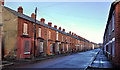
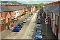
Frenchpark Street, Belfast (1)
A street, off Donegall Avenue Image, built over a number of years in the early 20th century. Most of the houses are now vacant pending redevelopment. This is the Donegall Avenue end with Kitchener Street on the right.
Image: © Albert Bridge
Taken: 10 Nov 2011
0.05 miles
10
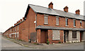
Donegall Avenue, Belfast (2)
Image: © Albert Bridge
Taken: 10 May 2009
0.05 miles