IMAGES TAKEN NEAR TO
Kitchener Drive, BELFAST, BT12 6LN
Introduction
This page details the photographs taken nearby to Kitchener Drive, BT12 6LN by members of the Geograph project.
The Geograph project started in 2005 with the aim of publishing, organising and preserving representative images for every square kilometre of Great Britain, Ireland and the Isle of Man.

There are currently over 7.5m images from over14,400 individuals and you can help contribute to the project by visiting https://www.geograph.org.uk
Image Map
Images are licensed for reuse under creativecommons.org/licenses/by-sa/2.0
Notes
- Clicking on the map will re-center to the selected point.
- The higher the marker number, the further away the image location is from the centre of the postcode.
Image Listing (168 Images Found)
Images are licensed for reuse under creativecommons.org/licenses/by-sa/2.0
Image
Details
Distance
1
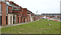
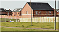
Vacant site, The Village, Belfast - January 2014 (1)
The view, south, from Kitchener Drive (Kitchener Street on the Google map) towards Windsor Park. The houses (left) are in Donegall Avenue. The vacant ground was the site of part of Kitchener Street Image
Image: © Albert Bridge
Taken: 30 Jan 2014
0.01 miles
2
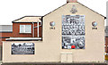
Young Citizens Volunteers mural, Belfast
A mural at Kitchener Drive (Kitchener Street on the Google map) commemorating the Young Citizens Volunteers (YCV) http://en.wikipedia.org/wiki/Young_Citizen_Volunteers_(1912).
Image: © Albert Bridge
Taken: 30 Jan 2014
0.02 miles
3
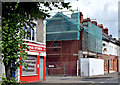
Renovation work, Donegall Avenue, Belfast (July 2014)
Renovation work now underway on this property Image (January 2014) at the corner of Kitchener Drive. Image is on the left.
Image: © Albert Bridge
Taken: 27 Jul 2014
0.02 miles
4
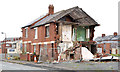
Surviving houses, The Village, Belfast
Three surviving houses at Kitchener Street. Kitchener Drive (Kitchener Street on the Google map) is in the background. Broadway is behind me.
Image: © Albert Bridge
Taken: 30 Jan 2014
0.02 miles
5
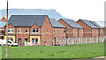
New houses, The Village, Belfast - February 2015(2)
New houses under construction between Soudan Street and Broadway Parade. For reference purposes Kitchener Street is at the bottom.
Image: © Albert Bridge
Taken: 23 Feb 2015
0.04 miles
6
New houses, The Village, Belfast - February 2015(1)
Redevelopment of The Village continuing along Kitchener Drive (Kitchener Street on the Google map), between Soudan Street and Broadway Parade. For reference purposes Kitchener Street is at bottom right.
Image: © Albert Bridge
Taken: 23 Feb 2015
0.04 miles
7
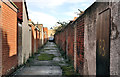
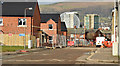
Back entry, Belfast (6)
Back entry, on the northern side of Broadway Image, between Soudan Street Image (left) and Kitchener Street Image
Image: © Albert Bridge
Taken: 10 Nov 2011
0.04 miles
8
New houses, The Village, Belfast - December 2014(1)
New houses, under construction, on what (I think) was the site of Soudan Street Image (November 2011).
Image: © Albert Bridge
Taken: 4 Dec 2014
0.05 miles
9
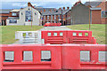
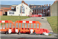
The Village redevelopment area, Belfast - July 2014(2)
The cleared area between Soudan Street and Donegall Avenue. Broadway is behind the barrier in the foreground. Kitchener Street runs straight ahead, towards Kitchener Drive. The vacant ground has been grassed pending the start of building (which is progressing in stages).
Image: © Albert Bridge
Taken: 27 Jul 2014
0.05 miles
10
Kitchener Street, Belfast (February 2015)
The line of the former Kitchener Street Image looking from Broadway towards Kitchener Drive (Kitchener Street on the Google map). Image is out of picture to the left.
Image: © Albert Bridge
Taken: 23 Feb 2015
0.05 miles