IMAGES TAKEN NEAR TO
Donegall Road, BELFAST, BT12 6FW
Introduction
This page details the photographs taken nearby to Donegall Road, BT12 6FW by members of the Geograph project.
The Geograph project started in 2005 with the aim of publishing, organising and preserving representative images for every square kilometre of Great Britain, Ireland and the Isle of Man.

There are currently over 7.5m images from over14,400 individuals and you can help contribute to the project by visiting https://www.geograph.org.uk
Image Map
Images are licensed for reuse under creativecommons.org/licenses/by-sa/2.0
Notes
- Clicking on the map will re-center to the selected point.
- The higher the marker number, the further away the image location is from the centre of the postcode.
Image Listing (134 Images Found)
Images are licensed for reuse under creativecommons.org/licenses/by-sa/2.0
Image
Details
Distance
1
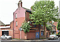
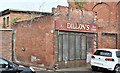
Nos 296-298 Donegall Road, Belfast - June 2016(1)
A long-term vacant property, now semi-derelict, at the corner of Kitchener Street – another of sites for which I have not been able to find any application for planning permission for redevelopment. Image shows the chimney.
Image: © Albert Bridge
Taken: 7 Jun 2016
0.03 miles
2
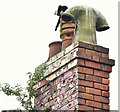
Nos 296-298 Donegall Road, Belfast - June 2016(2)
See Image A chimney with three pots - one fairly standard with a raised ring at the top, one louvred and one with a curved “H” top (my description).
Image: © Albert Bridge
Taken: 7 Jun 2016
0.03 miles
3
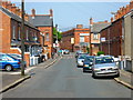
Soudan Street, Belfast
A street of terraced houses leading south from the Donegall Road in Belfast 12. View towards the Donegall Road/Rydalmere Street junction.
Image: © Dean Molyneaux
Taken: 29 Apr 2011
0.03 miles
4
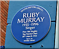
Ruby Murray blue plaque, Belfast (February 2019)
A plaque, at 337 Donegall Road, commemorating the singer Ruby Murray https://en.wikipedia.org/wiki/Ruby_Murray. The original Moltke Street http://www.geograph.org.uk/of/moltke+street+belfast no longer exists.
Image: © Albert Bridge
Taken: 17 Feb 2019
0.03 miles
5
No 2 Empire Street, Belfast (June 2016)
A disused single-storey former shop beside the Ulidia Image (right). The 1960 street directory shows it occupied by Kennedy Crossett, grocer.
Image: © Albert Bridge
Taken: 7 Jun 2016
0.04 miles
6
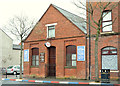
Donegall Road gospel hall, Belfast
A gospel hall, at the corner of Rydalmere Street, built between 1901 and 1907.
Image: © Albert Bridge
Taken: 8 Feb 2014
0.04 miles
7
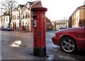
Pillar box, Belfast
GVIR pillar box at Donegall Avenue, opposite Pembroke Street.
Image: © Albert Bridge
Taken: 10 Nov 2011
0.04 miles
8
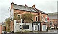
No 270 Donegall Road, Belfast (February 2019)
No 270 (right) is currently offered for sale.
Image: © Albert Bridge
Taken: 17 Feb 2019
0.04 miles
9
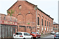
Former Ulidia factory, Belfast - June 2016(2)
See Image The Empire Street side.
Image: © Albert Bridge
Taken: 7 Jun 2016
0.05 miles
10
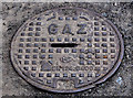
"Norwood" access cover, Belfast
An interesting find on the Donegall Road, near Richview Street. A small cover allowing access to a gas main. Marked “gaz” (French for “gas") and bearing the stylised trademark “NF” it seems of be a product of the Canadian Norwood Foundry http://www.norwoodfoundry.com/index.htm. (Well done Google!)
Image: © Albert Bridge
Taken: 16 May 2011
0.05 miles