IMAGES TAKEN NEAR TO
Grosvenor Road, BELFAST, BT12 6BN
Introduction
This page details the photographs taken nearby to Grosvenor Road, BT12 6BN by members of the Geograph project.
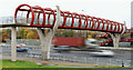
The Geograph project started in 2005 with the aim of publishing, organising and preserving representative images for every square kilometre of Great Britain, Ireland and the Isle of Man.

There are currently over 7.5m images from over14,400 individuals and you can help contribute to the project by visiting https://www.geograph.org.uk
Image Map
Images are licensed for reuse under creativecommons.org/licenses/by-sa/2.0
Notes
- Clicking on the map will re-center to the selected point.
- The higher the marker number, the further away the image location is from the centre of the postcode.
Image Listing (38 Images Found)
Images are licensed for reuse under creativecommons.org/licenses/by-sa/2.0
Image
Details
Distance
1
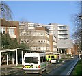
Royal Victoria Hospital
One of the Royal group of hospitals which occupies this large site.
Image: © Paul McIlroy
Taken: 8 Feb 2006
0.06 miles
2
The Falls Road
Looking back towards the city centre, the buildings in picture are part of The Royal Hospital complex.
Image: © Paul McIlroy
Taken: 8 Feb 2006
0.06 miles
3
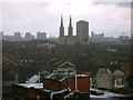
Belfast
This picture was taken from the sixth floor of The Royal Victoria Hospital
looking ENE. The prominent buildings in the centre are Divis flats and St. Peter's Cathedral Image
Image: © Paul McIlroy
Taken: 8 Feb 2006
0.06 miles
4
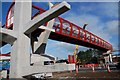
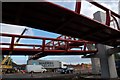
Footbridge, Westlink, Belfast (1)
See Image This footbridge (not yet in use) will cross the Westlink at Roden Street. Continue to Image
Image: © Albert Bridge
Taken: 25 Sep 2007
0.06 miles
5
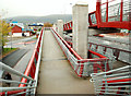
Footbridge, Westlink, Belfast (2)
See Image A view in the other direction showing the elaborate arrangements needed to make it suitable for wheelchairs and those with disabilities. Continue to Image
Image: © Albert Bridge
Taken: 25 Sep 2007
0.06 miles
6

Buildings of the Royal Hospitals viewed from the A12 Westlink
Image: © Eric Jones
Taken: 4 Jun 2016
0.06 miles
7
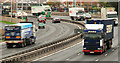
The Westlink, Belfast (8)
See Image The section of the Westlink (looking towards the M1) between Roden Street Image and Broadway. The countdown marker for the Broadway off-slip Image can be seen above the lorry on the left. Continue to Image
Image: © Albert Bridge
Taken: 18 Nov 2009
0.08 miles
8
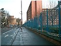
Roden Street footbridge, Belfast (3)
See Image The southern (Donegall Road) side of the bridge - looking towards the M1.
Image: © Albert Bridge
Taken: 18 Nov 2009
0.12 miles
9
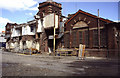
Royal Victoria Hospital, Belfast
This building houses the heating and ventilation plant for the largely demolished old hospital. This was a plenum system using steam driven fans and steam heating coils. This part is being retained.
Image: © Chris Allen
Taken: 1 Aug 2005
0.12 miles
10
Roden Street footbridge, Belfast (1)
See Image The bridge, as completed, seen from the northern side. Image shows the view, from the bridge, towards the M1. Continue to Image
Image: © Albert Bridge
Taken: 18 Nov 2009
0.12 miles