IMAGES TAKEN NEAR TO
Eureka Drive, BELFAST, BT12 5NR
Introduction
This page details the photographs taken nearby to Eureka Drive, BT12 5NR by members of the Geograph project.
The Geograph project started in 2005 with the aim of publishing, organising and preserving representative images for every square kilometre of Great Britain, Ireland and the Isle of Man.

There are currently over 7.5m images from over14,400 individuals and you can help contribute to the project by visiting https://www.geograph.org.uk
Image Map
Images are licensed for reuse under creativecommons.org/licenses/by-sa/2.0
Notes
- Clicking on the map will re-center to the selected point.
- The higher the marker number, the further away the image location is from the centre of the postcode.
Image Listing (382 Images Found)
Images are licensed for reuse under creativecommons.org/licenses/by-sa/2.0
Image
Details
Distance
1
Church of the Nazarene, Belfast
There are more than 90 such churches in the UK. This one is just off the Donegall Road, at Roseland Place.
Image: © Albert Bridge
Taken: 24 Sep 2010
0.02 miles
2
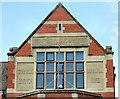
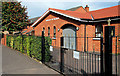
Carnegie library, Belfast (detail)
One of three in Belfast, this branch, on the Donegall Road, was built in 1909 to a design by Watt and Tulloch.
Image: © Albert Bridge
Taken: 24 May 2009
0.03 miles
3
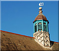
Library lantern, Belfast
On the roof of Donegall Road Image library.
Image: © Albert Bridge
Taken: 26 Nov 2009
0.03 miles
4
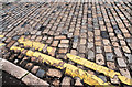
Setts, Belfast
Still in place at the Donegall Road end of Utility Street.
Image: © Albert Bridge
Taken: 11 Aug 2010
0.03 miles
5
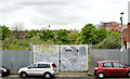
Development site, Utility Street, Belfast - May 2014(3)
The south eastern end of the site seen from the Donegall Road.
Image: © Albert Bridge
Taken: 8 May 2014
0.04 miles
6
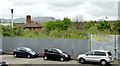
Development site, Utility Street, Belfast - May 2014(2)
The middle of the site seen from the Donegall Road.
Image: © Albert Bridge
Taken: 8 May 2014
0.04 miles
7
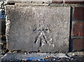
Bench Mark, Belfast
Cut bench mark located on the extreme south-western edge of a hall on the Donegall Road at the junction with Roseland Place.
See also http://www.geograph.org.uk/search.php?i=11037856 for many other examples I have found.
Image: © Rossographer
Taken: 4 Mar 2010
0.04 miles
8
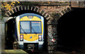
City Hospital station, Belfast (3)
See Image The 09.41 Londonderry – Belfast Gt Victoria Street, passing under the double-arch Donegall Road bridge, at the Portadown/Dublin end of the station. Continue to Image
Image: © Albert Bridge
Taken: 26 Nov 2009
0.04 miles
9
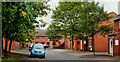
Eureka Drive, Belfast (1)
Eureka Drive runs from Tierney Gardens, off the Donegall Road, to Felt Street (background). Built on the line of Eureka Street which dated from around 1870 and ran from Tierney Street to Felt Street. At that time the Donegall Road was called Blackstaff Road having previously been Blackstaff Lane. The Blackstaff is a now-culverted river under Belfast Image See also Image
Image: © Albert Bridge
Taken: 24 Sep 2010
0.04 miles
10
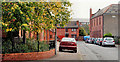
Eureka Drive, Belfast (2)
See Image The view in the other direction, towards Tierney Gardens, with the trees showing the signs of autumn.
Image: © Albert Bridge
Taken: 24 Sep 2010
0.04 miles