IMAGES TAKEN NEAR TO
Utility Street, BELFAST, BT12 5JS
Introduction
This page details the photographs taken nearby to Utility Street, BT12 5JS by members of the Geograph project.
The Geograph project started in 2005 with the aim of publishing, organising and preserving representative images for every square kilometre of Great Britain, Ireland and the Isle of Man.

There are currently over 7.5m images from over14,400 individuals and you can help contribute to the project by visiting https://www.geograph.org.uk
Image Map
Images are licensed for reuse under creativecommons.org/licenses/by-sa/2.0
Notes
- Clicking on the map will re-center to the selected point.
- The higher the marker number, the further away the image location is from the centre of the postcode.
Image Listing (265 Images Found)
Images are licensed for reuse under creativecommons.org/licenses/by-sa/2.0
Image
Details
Distance
1
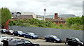
Development site, Utility Street, Belfast - May 2014(1)
The north western (Felt Street) end of the site seen from the Donegall Road.
Image: © Albert Bridge
Taken: 8 May 2014
0.00 miles
2
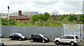
Development site, Utility Street, Belfast - May 2014(2)
The middle of the site seen from the Donegall Road.
Image: © Albert Bridge
Taken: 8 May 2014
0.01 miles
3
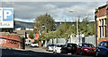
Development site, Utility Street, Belfast (October 2016)
This site, marked by the vegetation at middle right, remains vacant.
Image: © Albert Bridge
Taken: 2 Oct 2016
0.01 miles
4
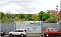
Development site, Utility Street, Belfast - May 2014(3)
The south eastern end of the site seen from the Donegall Road.
Image: © Albert Bridge
Taken: 8 May 2014
0.02 miles
5
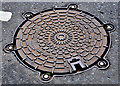
PAM Manhole cover, Belfast
A stylish PAM (Pont a Mousson, Saint Gobain Image) manhole cover, on the Donegall Road, opposite the back entrance to the City Hospital Image It is a “PAMETANCHE” cadre rond non ventilé with the “GS” mark Image and the trademark “NF” Image
Image: © Albert Bridge
Taken: 16 May 2011
0.02 miles
6
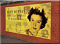
Ruby Murray plaque, Belfast (3)
Recently erected plaque, near Utility Street, on the Donegall Road, commemorating Ruby Murray.
Image: © Albert Bridge
Taken: 26 Aug 2012
0.03 miles
7
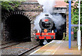
The "Portrush Flyer", Belfast (July 2014)
The first of this year’s three Railway Preservation Society of Ireland’s Belfast – Portrush “Portrush Flyer” trains, hauled by no 85 “Merlin” http://www.steamtrainsireland.com/locomotives/loco85.htm, passing under the Donegall Road bridge, at the City Hospital station. This is the only one booked to serve Gt Victoria Street.
Image: © Albert Bridge
Taken: 27 Jul 2014
0.03 miles
8
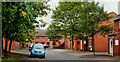
Eureka Drive, Belfast (1)
Eureka Drive runs from Tierney Gardens, off the Donegall Road, to Felt Street (background). Built on the line of Eureka Street which dated from around 1870 and ran from Tierney Street to Felt Street. At that time the Donegall Road was called Blackstaff Road having previously been Blackstaff Lane. The Blackstaff is a now-culverted river under Belfast Image See also Image
Image: © Albert Bridge
Taken: 24 Sep 2010
0.03 miles
9
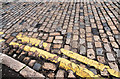
Setts, Belfast
Still in place at the Donegall Road end of Utility Street.
Image: © Albert Bridge
Taken: 11 Aug 2010
0.04 miles
10
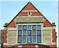
Carnegie library, Belfast (detail)
One of three in Belfast, this branch, on the Donegall Road, was built in 1909 to a design by Watt and Tulloch.
Image: © Albert Bridge
Taken: 24 May 2009
0.05 miles