IMAGES TAKEN NEAR TO
Schomberg Drive, BELFAST, BT12 5JE
Introduction
This page details the photographs taken nearby to Schomberg Drive, BT12 5JE by members of the Geograph project.
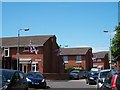
The Geograph project started in 2005 with the aim of publishing, organising and preserving representative images for every square kilometre of Great Britain, Ireland and the Isle of Man.

There are currently over 7.5m images from over14,400 individuals and you can help contribute to the project by visiting https://www.geograph.org.uk
Image Map
Images are licensed for reuse under creativecommons.org/licenses/by-sa/2.0
Notes
- Clicking on the map will re-center to the selected point.
- The higher the marker number, the further away the image location is from the centre of the postcode.
Image Listing (1042 Images Found)
Images are licensed for reuse under creativecommons.org/licenses/by-sa/2.0
Image
Details
Distance
1
Aughrim Park, Sandy Row
This is a residential area behind the main street of Sandy Row.
Image: © Eric Jones
Taken: 30 Jun 2015
0.01 miles
2
Maxwell Street, Belfast
For the background to Maxwell Street see Image The street seen from Sandy Row.
Image: © Albert Bridge
Taken: 30 Aug 2009
0.03 miles
3
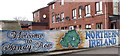
The "Welcome to Sandy Row" mural
This mural stands next to that paying homeage to the Northern Ireland Football Association.
Image: © Eric Jones
Taken: 17 Feb 2015
0.04 miles
4
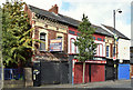
Nos 101-107 Sandy Row, Belfast
A terrace of what is now four properties on the northern side of City Walk – two occupied, one derelict and one offered for sale. Continue to Image
Image: © Albert Bridge
Taken: 9 Mar 2014
0.05 miles
5
Nos 101-109 Sandy Row, Belfast (October 2016)
See Image (March 2014). The same properties 2½ years later. The one on the left has a “for sale/to let” board. The same agents’ description for 105/107 includes “The unit is suitable for immediate occupation with minimal ingoing costs. Finishes include carpeted flooring, fluorescent strip lighting, roller shutters. The unit would be suitable for a wide variety of retail and office uses, subject to planning” and “The site previously had outline planning consent (Z/2008/0853/0) for a three-storey building incorporating 6 No. apartments and a retail unit on the ground floor.”
The numbers are not always displayed on commercial properties but the brochure seems to refer to the former electrical shop.
Image: © Albert Bridge
Taken: 2 Oct 2016
0.05 miles
6

City Way, Belfast
Part of the redeveloped area between Sandy Row and the Donegall Road. Built approximately on the line of the old City Street.
Image: © Albert Bridge
Taken: 23 Jun 2010
0.05 miles
7
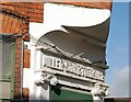
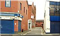
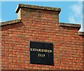
Doorway detail, Belfast
The doorway of a late 19th building at the corner of Maxwell Street (right) and Maxwell’s Place, off Sandy Row. The street seems to have been built in the late 1860’s with just six houses. By the turn of the century they had been replaced by three commercial premises. The one was a factory where Miller Son & Torrance Ltd carried on the business of collar, cuff & shirt manufacturers.
Image: © Albert Bridge
Taken: 25 Aug 2009
0.05 miles
8
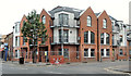
Albion Street housing site, Belfast (8)
New apartments, well advanced, at the corner of Sandy Row (foreground) and Albion Street.
Image: © Albert Bridge
Taken: 9 Sep 2012
0.05 miles
9
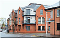
Albion Street housing site, Belfast (9)
The completed block, of social housing apartments, at the corner of Sandy Row and Albion Street. Image shows the site in June 2011.
Image: © Albert Bridge
Taken: 4 Nov 2012
0.05 miles
10
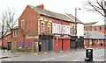
Reids Shoes, Belfast (2)
Image: © Albert Bridge
Taken: 20 Sep 2009
0.06 miles