IMAGES TAKEN NEAR TO
Charles Street South, BELFAST, BT12 5GB
Introduction
This page details the photographs taken nearby to Charles Street South, BT12 5GB by members of the Geograph project.
The Geograph project started in 2005 with the aim of publishing, organising and preserving representative images for every square kilometre of Great Britain, Ireland and the Isle of Man.

There are currently over 7.5m images from over14,400 individuals and you can help contribute to the project by visiting https://www.geograph.org.uk
Image Map
Images are licensed for reuse under creativecommons.org/licenses/by-sa/2.0
Notes
- Clicking on the map will re-center to the selected point.
- The higher the marker number, the further away the image location is from the centre of the postcode.
Image Listing (1435 Images Found)
Images are licensed for reuse under creativecommons.org/licenses/by-sa/2.0
Image
Details
Distance
1
Apartment blocks in Charles Street, Sandy Row
These luxury apartments and the nearby Days Hotel are visible signs of the city centre encroaching on the traditionally working class Loyalist residential area of Sandy Row.
Image]
Image: © Eric Jones
Taken: 30 Jun 2015
0.01 miles
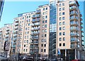
2
Victoria Place, Belfast (2008)
Victoria Place is a development of 161 apartments, nearing completion in Wellwood Street, between Gt Victoria Street and Sandy Row. See also Image and Image
Image: © Albert Bridge
Taken: 23 Mar 2008
0.01 miles
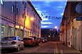
3
The rear of Charles Street South from Sandy Row
Charles Street South is a cul de sac. The building behind is a luxury apartment block.
Image: © Eric Jones
Taken: 17 Feb 2015
0.01 miles
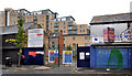
4
Charles Street South, Belfast
A narrow street running south off Wellwood Street (between Gt Victoria Street and Sandy Row). It makes an interesting contrast between the new Victoria Place building Image (left) and the traditional Belfast kitchen houses (right). Some of the streets around the area are used by all-day parkers to the dismay of local residents.
Image: © Albert Bridge
Taken: 8 Jan 2009
0.01 miles
5
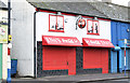
Caf?, Sandy Row, Belfast (December 2014)
Sit-in and carry out café – open early in the morning (except on a Sunday).
Image: © Albert Bridge
Taken: 14 Dec 2014
0.02 miles
6
No 96 Sandy Row, Belfast (October 2018)
A shop, previously selling band supplies (now moved to bigger premises), being converted to flats. The following planning permission (15 February 2017) applies “LA04/2016/2553/F External alterations and extension to existing building to create 2 1 bedroom apartments on upper floors. 96 Sandy Row Belfast BT12 5EX”.
Image: © Albert Bridge
Taken: 7 Oct 2018
0.02 miles
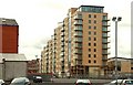
7
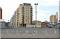
Victoria Place, Belfast (2013)
See Image (March 2008). The same block, seen from Hope Street. In the event of the site ever being developed this view would disappear. The City Hospital Image is at middle right.
Image: © Albert Bridge
Taken: 28 Jul 2013
0.02 miles
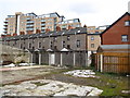
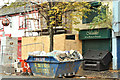
8
Albion Street housing site, Belfast (2)
The Sandy Row frontage with Scott Street Image behind the gates.
Image: © Albert Bridge
Taken: 5 Jun 2011
0.02 miles
9
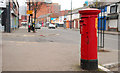
Pillar box, Belfast
EIIR pillar box in Sandy Row. Boyne Court and Gilpins Image are on the left.
Image: © Albert Bridge
Taken: 30 Jan 2011
0.02 miles
10
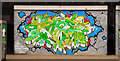
Former "Gilpins", Belfast (5)
See Image Graffiti on one of the roller shutter doors. The words at bottom left are “Thanks Belfast South Community Resources 2010”.
Image: © Albert Bridge
Taken: 30 Jan 2011
0.02 miles