IMAGES TAKEN NEAR TO
Napier Street, BELFAST, BT12 5FE
Introduction
This page details the photographs taken nearby to Napier Street, BT12 5FE by members of the Geograph project.
The Geograph project started in 2005 with the aim of publishing, organising and preserving representative images for every square kilometre of Great Britain, Ireland and the Isle of Man.

There are currently over 7.5m images from over14,400 individuals and you can help contribute to the project by visiting https://www.geograph.org.uk
Image Map
Images are licensed for reuse under creativecommons.org/licenses/by-sa/2.0
Notes
- Clicking on the map will re-center to the selected point.
- The higher the marker number, the further away the image location is from the centre of the postcode.
Image Listing (857 Images Found)
Images are licensed for reuse under creativecommons.org/licenses/by-sa/2.0
Image
Details
Distance
1
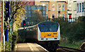
City Hospital station, Belfast (2)
See Image The station is served by suburban trains and those on the Londonderry line. The 09.35 “Enterprise” from Dublin is passing non-stop as it heads, through the cutting, towards the tunnel under the Lisburn Road and Bradbury Place. The Google map shows a non-existent bridge across the line close to here. Continue to Image
Image: © Albert Bridge
Taken: 26 Nov 2009
0.01 miles
2
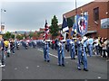
Parade along Donegal Road (1)
Staying overnight in the Day's Hotel, I was alerted to the noise of bands marching in the Sandy Road area.
Image: © Kenneth Allen
Taken: 26 Jul 2008
0.02 miles
3
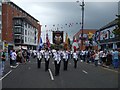
Parade along Donegal Road (2)
Another local band is taking part in the parade
Image: © Kenneth Allen
Taken: 26 Jul 2008
0.02 miles
4
Parade along Donegal Road (3)
Crowds were everywhere along the route
Image: © Kenneth Allen
Taken: 26 Jul 2008
0.02 miles
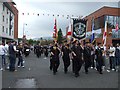
5
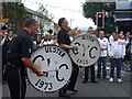
Parade along Donegal Road (4)
I think it must have been the case to see who made the loudest noise. (C.Y.C. = Cloughfern Young Conquerors)
Image: © Kenneth Allen
Taken: 26 Jul 2008
0.02 miles
6
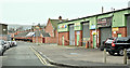
Gaffikin Street (proposed apartments) site, Belfast - March 2019(2)
The site (right), from Blondin Street, looking towards what was once Oban Street. Gaffikin Street seems to be named after Thomas Gaffikin - a director of the Ulster Spinning Company.
Image: © Albert Bridge
Taken: 3 Mar 2019
0.02 miles
7
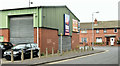
Gaffikin Street (proposed apartments) site, Belfast - March 2019(3)
The site (left), from Blondin Street, looking towards the Donegall Road.
Image: © Albert Bridge
Taken: 3 Mar 2019
0.02 miles
8
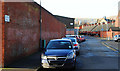
Gaffikin Street, Belfast
Originally Gaffikin’s Row, Gaffikin Street (off Sandy Row) was built in the mid 19th century and once had 73 houses. The name seems to come from the Gaffikin family some of whom were directors of the Ulster Spinning Co Ltd.
Image: © Albert Bridge
Taken: 26 Nov 2009
0.02 miles
9
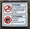
Sign at City Hospital railway halt
Sign at City Hospital - see Image
One of dozens that have recently been erected at stations across the Northern Ireland Railway network. From what I have seen they appear totally ineffectual at 'open air' halts such as this, particularly the 'No Smoking' element on platforms.
Image: © Rossographer
Taken: 21 Jan 2009
0.03 miles
10
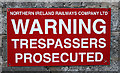
Sign at City Hospital railway halt
Warning sign near the end of a platform at Belfast City Hospital Image - you won't be prosecuted for standing on the platform, only if you walk off the end onto the tracks. See also Image
Image: © Rossographer
Taken: 18 Feb 2010
0.03 miles