IMAGES TAKEN NEAR TO
Plevna Park, BELFAST, BT12 4SS
Introduction
This page details the photographs taken nearby to Plevna Park, BT12 4SS by members of the Geograph project.
The Geograph project started in 2005 with the aim of publishing, organising and preserving representative images for every square kilometre of Great Britain, Ireland and the Isle of Man.

There are currently over 7.5m images from over14,400 individuals and you can help contribute to the project by visiting https://www.geograph.org.uk
Image Map
Images are licensed for reuse under creativecommons.org/licenses/by-sa/2.0
Notes
- Clicking on the map will re-center to the selected point.
- The higher the marker number, the further away the image location is from the centre of the postcode.
Image Listing (93 Images Found)
Images are licensed for reuse under creativecommons.org/licenses/by-sa/2.0
Image
Details
Distance
2
Falls Road Garden of Remembrance, Belfast
Image: © Nigel Thompson
Taken: 26 Jun 2017
0.13 miles
3
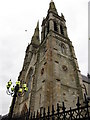
A side view of the twin spires of St Peter's Catholic Cathedral
Image: © Eric Jones
Taken: 20 May 2012
0.14 miles
4
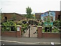
Republican garden of remembrance, Falls Road, Belfast
Image: © Robert Eva
Taken: 5 Aug 2017
0.14 miles
5
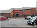
The Lower Falls Social and Recreation Club
This club stands on Grosvenor Road.
Image: © Eric Jones
Taken: 27 Apr 2012
0.14 miles
6
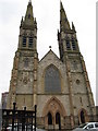
The front of St Peter's Catholic Cathedral
Image: © Eric Jones
Taken: 20 May 2012
0.15 miles
7
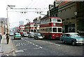
Belfast trolleybuses on Falls Road - 1968
A slow moving funeral cortege on its way to the City Cemetery has caused real problems for the bus service, with 7 vehicles now all bunched together. This must have been a regular headache for the City Transport department in attempting to maintain scheduled services. The view was taken during the last weeks of operation of trolleybuses in Belfast.
This section of Falls Road has changed beyond recognition, and indeed the only building visible here which still remains is the distant Divis Tower. On the right new housing has been developed, and on the left the industrial buildings have been replaced by a leisure centre and the Twin Spires complex.
This is one of a series of views featuring buses in the 60s, 70s, and 80s. http://www.geograph.org.uk/search.php?i=137652761
Image: © Alan Murray-Rust
Taken: 14 Apr 1968
0.15 miles
8
![Mural, Northumberland Street, Belfast [3]](https://s2.geograph.org.uk/photos/80/13/801302_23292249_120x120.jpg)
Mural, Northumberland Street, Belfast [3]
Another mural in Northumberland Street (Falls Road end) depicting a possible Bill of Rights. Northern Ireland still lacks an official Bill of Rights for its citizens - see http://www.borini.info/ for more information.
Image: © Rossographer
Taken: 14 May 2008
0.15 miles
9
![Mural, Northumberland Street, Belfast [2]](https://s1.geograph.org.uk/photos/80/12/801289_45c6b239_120x120.jpg)
Mural, Northumberland Street, Belfast [2]
Another mural in Northumberland Street (Falls Road end) depicting alleged atrocities by the Royal Irish Constabulary in the early 1920s in Belfast.
Image: © Rossographer
Taken: 14 May 2008
0.15 miles
10
![Mural, Northumberland Street, Belfast [1]](https://s0.geograph.org.uk/photos/80/12/801284_a709a07e_120x120.jpg)
Mural, Northumberland Street, Belfast [1]
Mural on Northumberland Street in Belfast (Falls Road end) depicting the dockers and carters strike of 1907.
Image: © Rossographer
Taken: 14 May 2008
0.15 miles