IMAGES TAKEN NEAR TO
Rosemary Street, BELFAST, BT1 1QB
Introduction
This page details the photographs taken nearby to Rosemary Street, BT1 1QB by members of the Geograph project.
The Geograph project started in 2005 with the aim of publishing, organising and preserving representative images for every square kilometre of Great Britain, Ireland and the Isle of Man.

There are currently over 7.5m images from over14,400 individuals and you can help contribute to the project by visiting https://www.geograph.org.uk
Image Map
Images are licensed for reuse under creativecommons.org/licenses/by-sa/2.0
Notes
- Clicking on the map will re-center to the selected point.
- The higher the marker number, the further away the image location is from the centre of the postcode.
Image Listing (3311 Images Found)
Images are licensed for reuse under creativecommons.org/licenses/by-sa/2.0
Image
Details
Distance
1
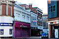
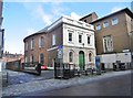
Rosemary Street, Belfast (3)
The three buildings at the Royal Avenue end of Rosemary Street seem to include those listed in the “Royal Exchange” planning application as “1485/DCA Demolition of Nos 43A-43B and 49-55 Rosemary Street, Belfast”. The redbrick one includes this detail Image See also Image
Image: © Albert Bridge
Taken: 5 Dec 2010
0.01 miles
2
Rosemary Street, Belfast (4)
See Image The same buildings seen along Rosemary Street. They seem to include those listed in the “Royal Exchange” planning application as “1485/DCA Demolition of Nos 43A-43B and 49-55 Rosemary Street, Belfast”. This church Image is on the right.
Image: © Albert Bridge
Taken: 5 Dec 2010
0.01 miles
3
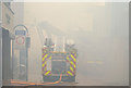
Fire, Rosemary Street, Belfast (11)
11.12 am. The view from Royal Avenue showing Rosemary Street almost hidden by smoke.
Image: © Albert Bridge
Taken: 18 Oct 2013
0.01 miles
4
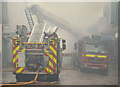
Fire, Rosemary Street, Belfast (12)
11.17 am. The heavy covering of smoke in Rosemary Street had cleared sufficiently to allow the three appliances to be seen. This view is from Royal Avenue.
Image: © Albert Bridge
Taken: 18 Oct 2013
0.01 miles
5
Belfast, First Presbyterian Church
On Rosemary Street; the building dates from 1783: http://www.nspresbyterian.org/pages/history.htm
Image: © Mike Faherty
Taken: 22 Apr 2018
0.01 miles
6
![First Presbyterian Church [1]](https://s0.geograph.org.uk/geophotos/04/54/82/4548204_4ea134d9_120x120.jpg)
First Presbyterian Church [1]
This delightful building was built in 1783, to the designs of Roger Mulholland, with a two-storey entrance block added circa 1833. The church is the oldest surviving place of worship within the old town boundary. Listed, grade A, with many details and much history at: http://www.doeni.gov.uk/niea/content-databases-buildview?id=4224
Image: © Michael Dibb
Taken: 8 Jun 2015
0.01 miles
7
![First Presbyterian Church [2]](https://s1.geograph.org.uk/geophotos/04/54/82/4548205_967aba4c_120x120.jpg)
First Presbyterian Church [2]
The information board adjacent to the church.
Image: © Michael Dibb
Taken: 8 Jun 2015
0.01 miles
8
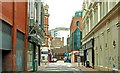
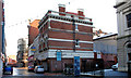
Berry Street, Belfast (1)
Like nearby Garfield Street Image, Berry Street mostly disappeared to make way for the Castle Court Image (left). The view is across Royal Avenue to Rosemary Street Image (background).
Image: © Albert Bridge
Taken: 18 Jan 2009
0.01 miles
9
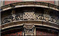
Datestone, Belfast
The date of completion of a substantial block, at the corner of Royal Avenue and Rosemary Street, set among ornate mouldings. The architect was Thomas Jackson.
Image: © Albert Bridge
Taken: 18 Oct 2009
0.01 miles
10
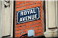
Royal Avenue sign, Belfast
Enamel sign at the corner of Rosemary Street.
Image: © Albert Bridge
Taken: 28 Mar 2010
0.01 miles