IMAGES TAKEN NEAR TO
Royal Avenue, BELFAST, BT1 1FD
Introduction
This page details the photographs taken nearby to Royal Avenue, BT1 1FD by members of the Geograph project.
The Geograph project started in 2005 with the aim of publishing, organising and preserving representative images for every square kilometre of Great Britain, Ireland and the Isle of Man.

There are currently over 7.5m images from over14,400 individuals and you can help contribute to the project by visiting https://www.geograph.org.uk
Image Map
Images are licensed for reuse under creativecommons.org/licenses/by-sa/2.0
Notes
- Clicking on the map will re-center to the selected point.
- The higher the marker number, the further away the image location is from the centre of the postcode.
Image Listing (3079 Images Found)
Images are licensed for reuse under creativecommons.org/licenses/by-sa/2.0
Image
Details
Distance
1
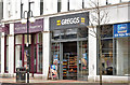
Greggs, Royal Avenue, Belfast (April 2018)
A Greggs branch at 51 Royal Avenue.
Image: © Albert Bridge
Taken: 8 Apr 2018
0.01 miles
2
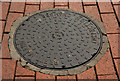
Brett Martin inspection cover, Belfast (2)
A Brett Martin http://www.geograph.org.uk/search.php?i=30961100 and Image inspection cover opposite the Castle Court, at Royal Avenue.
Image: © Albert Bridge
Taken: 29 Apr 2012
0.01 miles
3
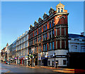
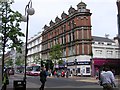
Nos 31-55 Royal Avenue, Belfast (1)
The eastern side of Royal Avenue, between Lower Garfield Street and Rosemary Street (right), includes two substantial Victorian buildings. The red one dates from 1882 Image and is by Thomas Jackson. The painted one (to its left) is by Young and Mackenzie in 1883. They are included in the “Royal Exchange” planning application as “1507/LBC 31-51 Royal Avenue, Belfast Renovation of buildings to provide retail units on ground and first floors and office space on upper floors; shop fronts to be rationalised and upgraded; elements of structure to the rear to be removed to allow through access to courtyard and new build extension to rear; extension to the rear of the block separated by an atrium and a shared covered space from second floor upwards; previously removed chimneys to be reinstated; and addition of substantial dormer to rear of existing roof to the stores” (LBC – listed building consent).
Image: © Albert Bridge
Taken: 5 Dec 2010
0.01 miles
4
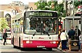
Single-deck bus, Belfast
See Image All single-deckers have not been replaced. This Wright Renown-bodied Volvo is calling at another of the stops at the Castle Court Image on service 12B – Carr’s Glen via Cliftonville (20 minutes).
Image: © Albert Bridge
Taken: 6 Jul 2009
0.01 miles
6
Royal Avenue, Belfast (2)
See Image Royal Avenue’s status declined with the bombing campaign in the early 70s, the closure of the Grand Central and Avenue hotels and the demise of Sinclair’s department store. The Castle Court Image (out of picture to the right) has restored life to the western side but the eastern side (this photo) remains quiet with no major “names” (save a small Argos) to draw the crowds. Continue to Image
Image: © Albert Bridge
Taken: 19 Sep 2008
0.02 miles
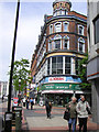
7
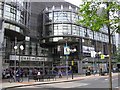
Castlecourt Shopping Centre
It is located to the north of the City Hall
Image: © Kenneth Allen
Taken: 13 May 2009
0.02 miles
8
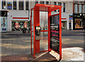
Telephone box, Belfast (20)
A Euro-payphone Limited telephone box outside the Castle Court in Royal Avenue.
Image: © Albert Bridge
Taken: 15 Apr 2012
0.02 miles
9
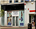
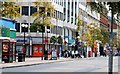
"To let" shop, Belfast (7)
A vacant shop, to let, at 47 Royal Avenue.
Image: © Albert Bridge
Taken: 6 May 2012
0.02 miles
10
Tourist Information Centre, Belfast
It is located at Royal Avenue
Image: © Kenneth Allen
Taken: 13 May 2009
0.02 miles