IMAGES TAKEN NEAR TO
Ladybrook Avenue, BELFAST, BT11 9EY
Introduction
This page details the photographs taken nearby to Ladybrook Avenue, BT11 9EY by members of the Geograph project.
The Geograph project started in 2005 with the aim of publishing, organising and preserving representative images for every square kilometre of Great Britain, Ireland and the Isle of Man.

There are currently over 7.5m images from over14,400 individuals and you can help contribute to the project by visiting https://www.geograph.org.uk
Image Map
Images are licensed for reuse under creativecommons.org/licenses/by-sa/2.0
Notes
- Clicking on the map will re-center to the selected point.
- The higher the marker number, the further away the image location is from the centre of the postcode.
Image Listing (7 Images Found)
Images are licensed for reuse under creativecommons.org/licenses/by-sa/2.0
Image
Details
Distance
1
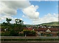
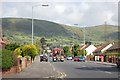
Ladybrook Parade.
Looking NW towards Black Hill. The TV mast belongs to the IBA.
Image: © Paul McIlroy
Taken: 22 Oct 2005
0.07 miles
2
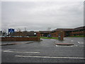
St. Genevieve's High School
This modern school has 1000 pupils and 67 staff.
Image: © Brian Shaw
Taken: 8 Nov 2005
0.07 miles
4
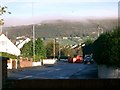
Finaghy Road North
Links Lisburn Road to Andersonstown Road, the view is towards the Black Mountain.
Image: © Paul McIlroy
Taken: 18 May 2007
0.20 miles
5
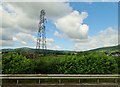
Power lines running parallel with the M1
Image: © Eric Jones
Taken: 21 Jun 2019
0.21 miles
6
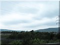
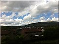
Woodland on the west side of the M1 at Finaghy
The Belfast Hills form the background.
Image: © Eric Jones
Taken: 4 Jun 2016
0.22 miles