IMAGES TAKEN NEAR TO
Owenvarragh Park, BELFAST, BT11 9BE
Introduction
This page details the photographs taken nearby to Owenvarragh Park, BT11 9BE by members of the Geograph project.
The Geograph project started in 2005 with the aim of publishing, organising and preserving representative images for every square kilometre of Great Britain, Ireland and the Isle of Man.

There are currently over 7.5m images from over14,400 individuals and you can help contribute to the project by visiting https://www.geograph.org.uk
Image Map
Images are licensed for reuse under creativecommons.org/licenses/by-sa/2.0
Notes
- Clicking on the map will re-center to the selected point.
- The higher the marker number, the further away the image location is from the centre of the postcode.
Image Listing (11 Images Found)
Images are licensed for reuse under creativecommons.org/licenses/by-sa/2.0
Image
Details
Distance
1
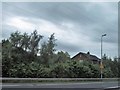
Houses in Owenvarragh Park, Andersonstown
The image was taken from the M1.
Image: © Eric Jones
Taken: 4 Jun 2016
0.11 miles
2
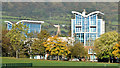
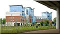
Apartments, Balmoral, Belfast (October 2014)
Apartments, at Stockman’s Way, with excellent views over Musgrave Park and the hills. Last seen in Image (June 2009).
Image: © Albert Bridge
Taken: 13 Oct 2014
0.12 miles
3
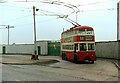
Belfast Trolleybus 229 at Casement Park - 1968
This was one of three terminal points for services along the Falls Road. This was the last remaining trolleybus route in Belfast, running across city to Whitewell and would cease operation 4 weeks after my visit.
The entrance to the stadium has since been rebuilt and the bus facility has been removed. The trolleybus is a BUT 9641T with locally built Harkness bodywork, built in 1954.
This is one of a series of views featuring buses in the 60s, 70s, and 80s. http://www.geograph.org.uk/search.php?i=137652761
Image: © Alan Murray-Rust
Taken: 13 Apr 1968
0.16 miles
4
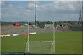
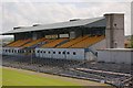
Roger Casement Park
Venue for Gaelic sports and headquarters to the County Antrim branch of The Gaelic Athletic Association (GAA)
Image: © Paul McIlroy
Taken: 18 May 2007
0.17 miles
6
The M1 at Stockman's Lane, Belfast (4)
See Image Musgrave Manor, apartments between Stockman’s Way and the roundabout, seen from under the flyover. There is quite a bit of landscaping on the roundabout (bottom). Continue to Image
Image: © Albert Bridge
Taken: 8 Jun 2009
0.19 miles
7
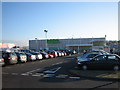
Asda store
Newly re-opened after conversion from Morrison's (formerly Safeway).
Image: © Brian Shaw
Taken: 17 Nov 2005
0.20 miles
8
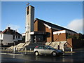
St. Agnes' Church Andersonstown
Celebrates its 50th anniversary this year.
Image: © Brian Shaw
Taken: 24 Nov 2005
0.20 miles
9
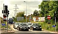
The M1 at Stockman's Lane, Belfast (6)
See Image Traffic, from the south and west, waiting at the lights at the off-slip. Continue to Image
Image: © Albert Bridge
Taken: 8 Jun 2009
0.24 miles
10
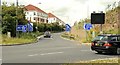
The M1 at Stockman's Lane, Belfast (5)
See Image The on-slip for traffic heading south and west, with the roundabout in the foreground. Continue to Image
Image: © Albert Bridge
Taken: 8 Jun 2009
0.25 miles