IMAGES TAKEN NEAR TO
Stockmans Park, BELFAST, BT11 9AX
Introduction
This page details the photographs taken nearby to Stockmans Park, BT11 9AX by members of the Geograph project.
The Geograph project started in 2005 with the aim of publishing, organising and preserving representative images for every square kilometre of Great Britain, Ireland and the Isle of Man.

There are currently over 7.5m images from over14,400 individuals and you can help contribute to the project by visiting https://www.geograph.org.uk
Image Map
Images are licensed for reuse under creativecommons.org/licenses/by-sa/2.0
Notes
- Clicking on the map will re-center to the selected point.
- The higher the marker number, the further away the image location is from the centre of the postcode.
Image Listing (20 Images Found)
Images are licensed for reuse under creativecommons.org/licenses/by-sa/2.0
Image
Details
Distance
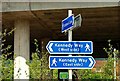
1
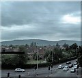
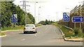
Kennedy Way, Anderstown
This image was taken from the northbound carriageway of the M1. The Belfast Hills form the background.
Image: © Eric Jones
Taken: 4 Jun 2016
0.08 miles
2
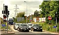
The M1 at Stockman's Lane, Belfast (6)
See Image Traffic, from the south and west, waiting at the lights at the off-slip. Continue to Image
Image: © Albert Bridge
Taken: 8 Jun 2009
0.08 miles
4
The M1 at Stockman's Lane, Belfast (7)
See Image Traffic from Kennedy Way waiting to join the roundabout. Kennedy way is part of the Outer Ring Road, running from the Monagh Bypass and the Springfield Road. Continue to Image
Image: © Albert Bridge
Taken: 8 Jun 2009
0.09 miles
5
The M1 at Stockman's Lane, Belfast (8)
See Image The on-slip used by traffic heading towards the city centre, the Westlink Image and the M2 Image This is probably the quietest part of the roundabout during the off-peak hours. Continue to Image
Image: © Albert Bridge
Taken: 8 Jun 2009
0.10 miles
6
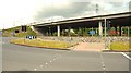
The M1 at Stockman's Lane, Belfast (1)
The M1 is the road used by all traffic, south and west to and from Belfast. Work started in 1959. The section between the roundabout at Celtic Park (now known as the Broadway roundabout) and Lisburn opened in 1962. At the time the junction at Stockman's Lane was of minor importance.
The march of time, the expansion of west Belfast, the building of the Outer Ring Road, the development of the Bog Meadows and surrounding land for retail and wholesale warehousing and the general increase in car ownership meant that the motorway and roundabout were not equipped for the present volume of traffic.
The section from Broadway to here had a third lane added as part of the Westlink contract Image The flyover was widened; the roundabout rebuilt and is now controlled by traffic lights.
There is also quite an elaborate system of “green men” and railings for the safety of the few pedestrians who have to cross.
This is the flyover as it crosses Stockmans Lane. Lisburn and Dungannon are to the left.
The “green man” aspect has provided a few moments of respite in which to view the roundabout without traffic. Continue to Image
Image: © Albert Bridge
Taken: 8 Jun 2009
0.11 miles
7
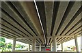
The M1 at Stockman's Lane, Belfast (10)
Image: © Albert Bridge
Taken: 8 Jun 2009
0.12 miles
8
The M1 at Stockman's Lane, Belfast (5)
See Image The on-slip for traffic heading south and west, with the roundabout in the foreground. Continue to Image
Image: © Albert Bridge
Taken: 8 Jun 2009
0.12 miles
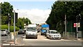
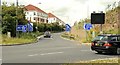
9
The M1 at Stockman's Lane, Belfast (11)
See Image The few pedestrians crossing the roundabout are regulated by railings and “green men”. They may use both the inside and outside. This sign is inside the roundabout, on the Stockman’s Lane side. There is no special provision for cyclists. The height of the new landscaping is of note.
Image: © Albert Bridge
Taken: 8 Jun 2009
0.13 miles
10
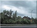
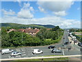
Houses in Owenvarragh Park, Andersonstown
The image was taken from the M1.
Image: © Eric Jones
Taken: 4 Jun 2016
0.13 miles