IMAGES TAKEN NEAR TO
Andersonstown Park, BELFAST, BT11 8FG
Introduction
This page details the photographs taken nearby to Andersonstown Park, BT11 8FG by members of the Geograph project.
The Geograph project started in 2005 with the aim of publishing, organising and preserving representative images for every square kilometre of Great Britain, Ireland and the Isle of Man.

There are currently over 7.5m images from over14,400 individuals and you can help contribute to the project by visiting https://www.geograph.org.uk
Image Map
Images are licensed for reuse under creativecommons.org/licenses/by-sa/2.0
Notes
- Clicking on the map will re-center to the selected point.
- The higher the marker number, the further away the image location is from the centre of the postcode.
Image Listing (6 Images Found)
Images are licensed for reuse under creativecommons.org/licenses/by-sa/2.0
Image
Details
Distance
1
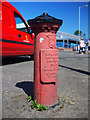
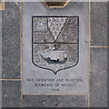
Boundary Post, Belfast
An old Belfast boundary post located on Andersonstown Road, Belfast.
The inscription reads
"Parliamentary
and Municipal Boundary of
Belfast
St Anne's Division
St Anne's Ward
1918".
Image: © Rossographer
Taken: 27 Jul 2011
0.12 miles
2
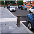
Boundary Post, Belfast
An old boundary post on the Glen Road in Belfast. This one is quite nice - the street and footpath have recently been improved and the paving directly in front of the post incorporates details from the post itself.
The inscription reads:
"Parliamentary and Municipal Boundary of Belfast
Falls Division, Falls Ward 1918".
Image: © Rossographer
Taken: 21 Aug 2012
0.21 miles
3
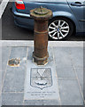
Boundary Post, Belfast
An old boundary post on the Glen Road in Belfast. This one is quite nice - the street and footpath have recently been improved and the paving directly in front of the post incorporates details from the post itself.
The inscription reads:
"Parliamentary and Municipal Boundary of Belfast
Falls Division, Falls Ward 1918".
Image: © Rossographer
Taken: 21 Aug 2012
0.21 miles
4
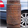
Boundary Post, Belfast
An old boundary post on the Glen Road in Belfast. This one is quite nice - the street and footpath have recently been improved and the paving directly in front of the post incorporates details from the post itself.
The inscription reads:
"Parliamentary and Municipal Boundary of Belfast
Falls Division, Falls Ward 1918".
Image: © Rossographer
Taken: 21 Aug 2012
0.21 miles
5
Boundary Post, Belfast
An old boundary post on the Glen Road in Belfast. This one is quite nice - the street and footpath have recently been improved and the paving directly in front of the post incorporates details from the post itself.
The inscription reads:
"Parliamentary and Municipal Boundary of Belfast
Falls Division, Falls Ward 1918".
Image: © Rossographer
Taken: 21 Aug 2012
0.21 miles
6
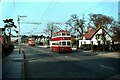
Belfast trolleybuses on Falls Road - 1968
Heading to the Casement Park terminus on service 12 with Milltown Cemetery in the background. This was part of the last remaining trolleybus route in Belfast, running across city to Whitewell and would cease operation 4 weeks after my visit. The building to the right has been replaced by a Sainsbury's superstore.
The leading trolleybus is no.197, a BUT 9641T with locally built Harkness bodywork, built in 1949.
This is one of a series of views featuring buses in the 60s, 70s, and 80s. http://www.geograph.org.uk/search.php?i=137652761
Image: © Alan Murray-Rust
Taken: 14 Apr 1968
0.24 miles