IMAGES TAKEN NEAR TO
Glen Road, BELFAST, BT11 8BB
Introduction
This page details the photographs taken nearby to Glen Road, BT11 8BB by members of the Geograph project.
The Geograph project started in 2005 with the aim of publishing, organising and preserving representative images for every square kilometre of Great Britain, Ireland and the Isle of Man.

There are currently over 7.5m images from over14,400 individuals and you can help contribute to the project by visiting https://www.geograph.org.uk
Image Map
Images are licensed for reuse under creativecommons.org/licenses/by-sa/2.0
Notes
- Clicking on the map will re-center to the selected point.
- The higher the marker number, the further away the image location is from the centre of the postcode.
Image Listing (28 Images Found)
Images are licensed for reuse under creativecommons.org/licenses/by-sa/2.0
Image
Details
Distance
1
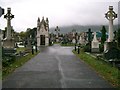
Milltown Cemetery
Looking westward to a cloud covered Black Hill.
Image: © Paul McIlroy
Taken: 21 Oct 2005
0.03 miles
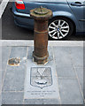
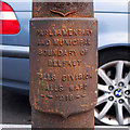
2
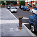
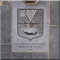
Boundary Post, Belfast
An old boundary post on the Glen Road in Belfast. This one is quite nice - the street and footpath have recently been improved and the paving directly in front of the post incorporates details from the post itself.
The inscription reads:
"Parliamentary and Municipal Boundary of Belfast
Falls Division, Falls Ward 1918".
Image: © Rossographer
Taken: 21 Aug 2012
0.13 miles
3
Boundary Post, Belfast
An old boundary post on the Glen Road in Belfast. This one is quite nice - the street and footpath have recently been improved and the paving directly in front of the post incorporates details from the post itself.
The inscription reads:
"Parliamentary and Municipal Boundary of Belfast
Falls Division, Falls Ward 1918".
Image: © Rossographer
Taken: 21 Aug 2012
0.13 miles
4
Boundary Post, Belfast
An old boundary post on the Glen Road in Belfast. This one is quite nice - the street and footpath have recently been improved and the paving directly in front of the post incorporates details from the post itself.
The inscription reads:
"Parliamentary and Municipal Boundary of Belfast
Falls Division, Falls Ward 1918".
Image: © Rossographer
Taken: 21 Aug 2012
0.13 miles
5
Boundary Post, Belfast
An old boundary post on the Glen Road in Belfast. This one is quite nice - the street and footpath have recently been improved and the paving directly in front of the post incorporates details from the post itself.
The inscription reads:
"Parliamentary and Municipal Boundary of Belfast
Falls Division, Falls Ward 1918".
Image: © Rossographer
Taken: 21 Aug 2012
0.13 miles
6
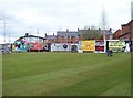
Turfing the site of the former Andersonstown RUC Barracks
This site has been designated as the site of a new landmark building for expowest, located as it is at the intersection of the Falls and Glen Road. The building design was the subject of an RIBA competition but the result has been challenged so that work is yet to begin.
http://www.architecture.com/Files/RIBAProfessionalServices/CompetitionsOffice/LiveCompetitions/Finalprelimbrief.pdf
http://www.expowestbelfast.com/
Image: © Eric Jones
Taken: 27 Apr 2012
0.13 miles
7
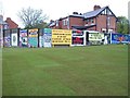
Billboards on the perimeter wall of the site of the former Andersonstown RUC barracks
Image: © Eric Jones
Taken: 27 Apr 2012
0.14 miles
8
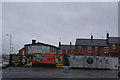
Murals down the Falls Road
Political campaigns are still being conducted, but I understand the authorities have tried to broaden the focus.
Image: © Bill Boaden
Taken: 12 Dec 2008
0.15 miles
9
McEnany's Bar on the corner of Glen Road and Divis Drive
This is the nearest watering hole to Milltown Cemetery.
Image: © Eric Jones
Taken: 27 Apr 2012
0.15 miles
10
The B102 (Falls Road) south of the junction with Glen Road
This section of the Falls Road leads on to the housing estates of Andersonstown.
Image: © Eric Jones
Taken: 27 Apr 2012
0.15 miles