IMAGES TAKEN NEAR TO
Glendale Mews, BELFAST, BT10 0PG
Introduction
This page details the photographs taken nearby to Glendale Mews, BT10 0PG by members of the Geograph project.
The Geograph project started in 2005 with the aim of publishing, organising and preserving representative images for every square kilometre of Great Britain, Ireland and the Isle of Man.

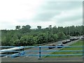
There are currently over 7.5m images from over14,400 individuals and you can help contribute to the project by visiting https://www.geograph.org.uk
Image Map
Images are licensed for reuse under creativecommons.org/licenses/by-sa/2.0
Notes
- Clicking on the map will re-center to the selected point.
- The higher the marker number, the further away the image location is from the centre of the postcode.
Image Listing (26 Images Found)
Images are licensed for reuse under creativecommons.org/licenses/by-sa/2.0
Image
Details
Distance
1
Black's Road, Dunmurry (2)
See Image Beyond the motorway junction, Black’s Road reverts to a standard suburban road.
Image: © Albert Bridge
Taken: 11 Jun 2009
0.05 miles
2
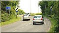
The Old Golf Course Road, Dunmurry
The Old Golf Course Road (shown as “Black’s Road Link” on the Google map) is part of the Dunmurry bypass. This is the road at its junction with Black’s Road Image
Image: © Albert Bridge
Taken: 11 Jun 2009
0.11 miles
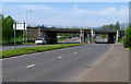
3
The M1 at Black's Road, Dunmurry (2)
See Image The on-slip.
Image: © Albert Bridge
Taken: 11 Jun 2009
0.14 miles
4
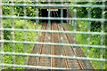
Railway between Dunmurry and Finaghy
There was a time when a railway enthusiast could stand here, prop his elbows on the bridge and photograph passing trains. The new bridge carrying the rebuilt Black’s Road Image across the railway stopped that. The view is towards Belfast.
Image: © Albert Bridge
Taken: 11 Jun 2009
0.14 miles
5
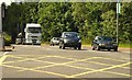
Traffic on the Blacks Road
The image was from the M1.
Image: © Eric Jones
Taken: 4 Jun 2016
0.16 miles
6
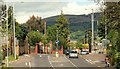
Black's Road, Belfast
Looking west along Black's Road. The M1 motorway crosses above. Quiet in mid-afternoon, the road features daily on rush hour traffic reports.
Image: © Rossographer
Taken: 6 May 2008
0.18 miles
7
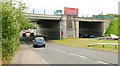
Black's Road flyover, Dunmurry
The rebuilt flyover carrying the M1 (Belfast to the left) across Black’s Road Image
Image: © Albert Bridge
Taken: 11 Jun 2009
0.19 miles
8
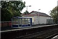
New passenger waiting shelter #1
New style passenger waiting shelter erected recently at Dunmurry Station. I wonder how long it will remain in this condition ?.
Image: © Wilson Adams
Taken: 22 Sep 2007
0.19 miles
9
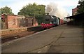
Dunmurry Station 1987
Dunmurry station as it was in 1987, The station building was constructed by the GNRI, and remained in use up until 1969/70 when it was reduced to a Halt and the station master duties (selling tickets etc) were transferred to the travelling guards on the trains.
Image: © Wilson Adams
Taken: 3 Oct 1987
0.19 miles
10
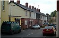
Railway Street, Dunmurry #1
Lefthand view of Railway Street, Dunmurry
Image: © Wilson Adams
Taken: 22 Sep 2007
0.19 miles