IMAGES TAKEN NEAR TO
Upper Lisburn Road, BELFAST, BT10 0LE
Introduction
This page details the photographs taken nearby to Upper Lisburn Road, BT10 0LE by members of the Geograph project.
The Geograph project started in 2005 with the aim of publishing, organising and preserving representative images for every square kilometre of Great Britain, Ireland and the Isle of Man.

There are currently over 7.5m images from over14,400 individuals and you can help contribute to the project by visiting https://www.geograph.org.uk
Image Map
Images are licensed for reuse under creativecommons.org/licenses/by-sa/2.0
Notes
- Clicking on the map will re-center to the selected point.
- The higher the marker number, the further away the image location is from the centre of the postcode.
Image Listing (12 Images Found)
Images are licensed for reuse under creativecommons.org/licenses/by-sa/2.0
Image
Details
Distance
1
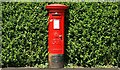
Pillar box, Finaghy, Belfast
A GR pillar box, recessed in a garden hedge, beside the Upper Lisburn Road, Finaghy.
Image: © Albert Bridge
Taken: 11 Jun 2009
0.15 miles
2
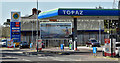
Topaz petrol station, Finaghy, Belfast (April 2016)
Topaz petrol station on the Upper Lisburn Road.
Image: © Albert Bridge
Taken: 22 Apr 2016
0.16 miles
3
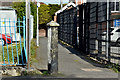
Concrete bollard, Finaghy, Belfast (April 2016)
A concrete bollard at the Upper Lisburn Road end of a path from Larkfield Avenue.
Image: © Albert Bridge
Taken: 22 Apr 2016
0.16 miles
4
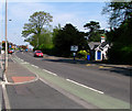
Upper Lisburn Road, Belfast
Looking back in the direction of central Belfast along the Upper Lisburn Road at Finaghy.
Image: © Rossographer
Taken: 6 May 2008
0.17 miles
5
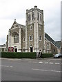
Lowe Memorial Presbyterian Church
Built in 1935 on the Upper Lisburn Road at Finaghy.
Image: © Brian Shaw
Taken: 18 Oct 2005
0.17 miles
6
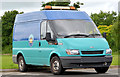
Ford Transit, Finaghy, Belfast
A Ford Transit van http://en.wikipedia.org/wiki/Ford_Transit , in Belfast City Council livery, parked at the Wedderburn Park playing fields.
Image: © Albert Bridge
Taken: 4 Jul 2013
0.17 miles
7
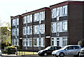
Orpen Drive, Finaghy, Belfast (April 2016)
There are several of these blocks of flats in the area between Finaghy Road South and the Upper Lisburn Road. To the best of my knowledge they were built in the 1960’s to a design which has lasted well.
Image: © Albert Bridge
Taken: 22 Apr 2016
0.17 miles
8
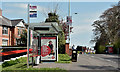
Black's Road bus shelter, Finaghy, Belfast (April 2016)
Bus shelter and stop on the Upper Lisburn Road close to Black’s Road. Served by numerous Ulsterbus services and some Metro buses to Seymour Hill and the Conway estate.
Image: © Albert Bridge
Taken: 22 Apr 2016
0.18 miles
9
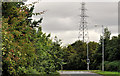
Pylon and power lines, Dunmurry (4)
Subject to the accuracy of my map reading, the line is a continuation, of this one Image The view is from Kingsway, across Black’s Road to where the pylon stands, behind houses, close to The Hawthorns and the Upper Lisburn Road, Finaghy. Continue to Image
Image: © Albert Bridge
Taken: 1 Aug 2011
0.20 miles
10
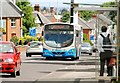
Bus, Finaghy, Belfast
A Wright-bodied Scania makes its way along the Upper Lisburn Road, at Finaghy, with the 12.10 service from Belfast (Upper Queen Street) Image to the Ballymacash estate, Lisburn.
Image: © Albert Bridge
Taken: 11 Jun 2009
0.21 miles