IMAGES TAKEN NEAR TO
Ardmore Park, BELFAST, BT10 0JL
Introduction
This page details the photographs taken nearby to Ardmore Park, BT10 0JL by members of the Geograph project.
The Geograph project started in 2005 with the aim of publishing, organising and preserving representative images for every square kilometre of Great Britain, Ireland and the Isle of Man.

There are currently over 7.5m images from over14,400 individuals and you can help contribute to the project by visiting https://www.geograph.org.uk
Image Map
Images are licensed for reuse under creativecommons.org/licenses/by-sa/2.0
Notes
- Clicking on the map will re-center to the selected point.
- The higher the marker number, the further away the image location is from the centre of the postcode.
Image Listing (26 Images Found)
Images are licensed for reuse under creativecommons.org/licenses/by-sa/2.0
Image
Details
Distance
1
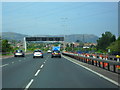
M1 at Finaghy
At this point, only three miles from the end (Broadway) and edging into urban Belfast, the M1 gains an extra lane. The exit signposted in the distance is Junction 2 (A55 Stockman's Lane).
Image: © Dean Molyneaux
Taken: 12 Sep 2009
0.05 miles
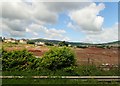
2
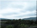
Woodland on the west side of the M1 at Finaghy
The Belfast Hills form the background.
Image: © Eric Jones
Taken: 4 Jun 2016
0.11 miles
3
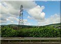
Power lines running parallel with the M1
Image: © Eric Jones
Taken: 21 Jun 2019
0.11 miles
4
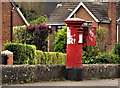
Pillar box and drop box, Finaghy, Belfast
GVIR pillar box, with drop box attached, opposite Ardmore Park South, Finaghy Road North.
Image: © Albert Bridge
Taken: 16 Sep 2011
0.13 miles
5
![Finaghy Road North, Belfast [1]](https://s3.geograph.org.uk/photos/70/71/707131_2a2891d9_120x120.jpg)
Finaghy Road North, Belfast [1]
Looking west, the road rises as it passes over the railway line and Finaghy halt seen in Image]
Image: © Rossographer
Taken: 28 Feb 2008
0.16 miles
6
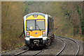
Train, Finaghy, Belfast (2012-1)
C3K set 3002, forming the 10.27 Bangor – Portadown, had just departed Finaghy and was heading towards Dunmurry, through the cutting before the M1 bridge near Black’s Road Image The long lens exaggerates the curve.
Image: © Albert Bridge
Taken: 17 Dec 2012
0.17 miles
8
![Finaghy Road North, Belfast [2]](https://s2.geograph.org.uk/photos/70/71/707134_fb6d598f_120x120.jpg)
Finaghy Road North, Belfast [2]
Looking west towards Anderstown, the M1 passes over Finaghy Road North.
Image: © Rossographer
Taken: 28 Feb 2008
0.18 miles
9
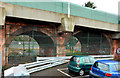
Railway arches, Finaghy, Belfast (2)
See Image In the early part of the 20th century, before the coming of the motor lorry, when the railway companies had what amounted to a monopoly of land transport, the GNR(I) made provision for adding additional capacity on the line beyond Belfast. It had built the third line Image (now removed) to the new workshops at Adelaide in 1911.
Around the same time it provided two new arches at Finaghy station, under Finaghy Road North Image, and one on the Ballinderry Road, Lisburn Image where a new bridge replaced a level crossing. The scheme was abandoned with the advent of the WW1.
The park and ride car park Image (right) was originally sidings (though not in my time).
Image: © Albert Bridge
Taken: 17 Dec 2012
0.18 miles
10
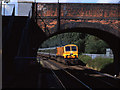
Train approaching Finaghy station
An Irish Rail 201 class locomotive brings the 07.40 Dublin - Belfast passenger train towards Finaghy station. For an earlier view, see Image
Image: © The Carlisle Kid
Taken: 11 Jul 2002
0.18 miles