IMAGES TAKEN NEAR TO
Diamond Avenue, BELFAST, BT10 0HG
Introduction
This page details the photographs taken nearby to Diamond Avenue, BT10 0HG by members of the Geograph project.
The Geograph project started in 2005 with the aim of publishing, organising and preserving representative images for every square kilometre of Great Britain, Ireland and the Isle of Man.

There are currently over 7.5m images from over14,400 individuals and you can help contribute to the project by visiting https://www.geograph.org.uk
Image Map
Images are licensed for reuse under creativecommons.org/licenses/by-sa/2.0
Notes
- Clicking on the map will re-center to the selected point.
- The higher the marker number, the further away the image location is from the centre of the postcode.
Image Listing (43 Images Found)
Images are licensed for reuse under creativecommons.org/licenses/by-sa/2.0
Image
Details
Distance
1
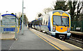
Train, Finaghy, Belfast (2012-2)
C3K set 3005 calling at Finaghy with the 10.45 Portadown – Bangor. The cant, on the curve, can be appreciated by comparing the verticals on the passenger shelter (left) and the train.
Image: © Albert Bridge
Taken: 17 Dec 2012
0.04 miles
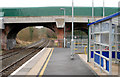
2
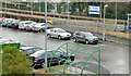
Park and ride car park, Finaghy station, Belfast
The park and ride car park at Finaghy station. It opened in September 2011. There is also provision for bicycles. Translink does not carry bicycles, on trains, before 09.30 Monday-Friday.
Image: © Albert Bridge
Taken: 17 Dec 2012
0.04 miles
3
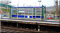
Shelter, Finaghy station, Belfast
See Image The shelter, with the graffiti removed and not quite so intimidating.
Image: © Albert Bridge
Taken: 28 Jan 2010
0.04 miles
4
![Train departing, Finaghy station Belfast [1]](https://s2.geograph.org.uk/photos/70/71/707126_6aa0cf75_120x120.jpg)
Train departing, Finaghy station Belfast [1]
1245 Portadown - Bangor service departing Finaghy at 1321.
Image: © Rossographer
Taken: 28 Feb 2008
0.05 miles
5
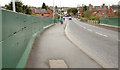
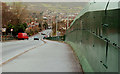
Railway bridge, Finaghy, Belfast (2)
See Image The bridge, at Finaghy Road North (looking towards Finaghy Crossroads), showing the safety barrier erected in 2008. The station is to the left.
Image: © Albert Bridge
Taken: 28 Jan 2010
0.06 miles
6
Railway bridge, Finaghy, Belfast
See Image The bridge, at Finaghy Road North (looking towards Ladybrook), showing the safety barrier erected in 2008. The station is to the right.
Image: © Albert Bridge
Taken: 28 Jan 2010
0.06 miles
7
Finaghy station, Belfast (2)
Finaghy station looking towards Lisburn. Taken to be as close as possible to Image from more than 39 years earlier. The line opened in 1839. Finaghy station came much later – in 1907.
The bridge (Finaghy Road North) was built in 1911 with a third arch intended (the story goes) in case it ever became necessary to extend the Third Line Image to Lisburn. It was substantially altered in 2008 by “replacing existing walls and fences . . . . with high standard safety barriers”.
Image: © Albert Bridge
Taken: 28 Jan 2010
0.06 miles
8
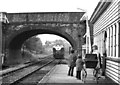
Finaghy station, Belfast (1970)
See Image Finaghy station was not always in such condition. When this was taken it still retained a standard GNR(I) shelter and wooden platforms. The permanent way included flat-bottomed rail on wooden sleepers on the down line and bullhead rail on the up line (left). The view is towards Lisburn as a CIE locomotive runs light to Belfast Grosvenor Road goods yard. Image shows a similar view in 2010.
Image: © Albert Bridge
Taken: 3 Oct 1970
0.06 miles
9
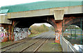
Railway arches, Finaghy, Belfast (1)
The arch, on the bridge under Finaghy Road North Image, on the Lisburn/Dublin side of Finaghy station. There are another two on the right. Their origin is explained in Image
Image: © Albert Bridge
Taken: 17 Dec 2012
0.06 miles
10
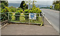
Truncated footpath, Belfast
The footpath, on the south western side of Finaghy Road North, disappears on the approach to the railway bridge Image and reappears on the other side.
Image: © Albert Bridge
Taken: 16 Sep 2011
0.06 miles