IMAGES TAKEN NEAR TO
The Hill, BELFAST, BT10 0GH
Introduction
This page details the photographs taken nearby to The Hill, BT10 0GH by members of the Geograph project.
The Geograph project started in 2005 with the aim of publishing, organising and preserving representative images for every square kilometre of Great Britain, Ireland and the Isle of Man.

There are currently over 7.5m images from over14,400 individuals and you can help contribute to the project by visiting https://www.geograph.org.uk
Image Map
Images are licensed for reuse under creativecommons.org/licenses/by-sa/2.0
Notes
- Clicking on the map will re-center to the selected point.
- The higher the marker number, the further away the image location is from the centre of the postcode.
Image Listing (4 Images Found)
Images are licensed for reuse under creativecommons.org/licenses/by-sa/2.0
Image
Details
Distance
1
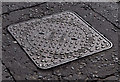
Sidney Smith manhole cover, Finaghy, Belfast
A Sidney Smith Image “Nimbus” manhole cover, at Finaghy Road South, near Chippendale Gardens.
Image: © Albert Bridge
Taken: 6 Jul 2011
0.24 miles
2
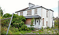
Nos 140-142 Finaghy Road South, Belfast
Two houses with an agents’ board advertising “Coming soon 4 contemporary detached family homes”. No 142 is on the right. This photograph appears as a matter of record only. I have no connection with any of the parties involved in the development. See also Image
Image: © Albert Bridge
Taken: 4 Jul 2013
0.25 miles
3
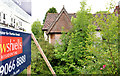
No 144 Finaghy Road South, Belfast
See Image A house with an agents’ board advertising “Coming soon 4 contemporary detached family homes”. This photograph appears as a matter of record only. I have no connection with any of the parties involved in the development.
Image: © Albert Bridge
Taken: 4 Jul 2013
0.25 miles
4
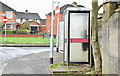
Telephone box, Erinvale, Finaghy, Belfast (January 2015)
A KX100 telephone box at Erinvale Avenue.
Image: © Albert Bridge
Taken: 4 Jan 2015
0.25 miles