IMAGES TAKEN NEAR TO
Geeragh Place, BELFAST, BT10 0ER
Introduction
This page details the photographs taken nearby to Geeragh Place, BT10 0ER by members of the Geograph project.
The Geograph project started in 2005 with the aim of publishing, organising and preserving representative images for every square kilometre of Great Britain, Ireland and the Isle of Man.

There are currently over 7.5m images from over14,400 individuals and you can help contribute to the project by visiting https://www.geograph.org.uk
Image Map
Images are licensed for reuse under creativecommons.org/licenses/by-sa/2.0
Notes
- Clicking on the map will re-center to the selected point.
- The higher the marker number, the further away the image location is from the centre of the postcode.
Image Listing (21 Images Found)
Images are licensed for reuse under creativecommons.org/licenses/by-sa/2.0
Image
Details
Distance
1
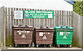
Recycling bins, Finaghy, Belfast
Recycling bins for glass at Benmore Drive, at the entrance to Taughmonagh.
Image: © Albert Bridge
Taken: 4 Jul 2013
0.06 miles
2
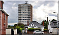
Moylena House, Finaghy, Belfast
One of two adjacent and identical tower blocks, in the Taughmonagh estate Image, built for the Northern Ireland Housing Trust in the early 1960’s. The view is from Orpen Park, Finaghy Road South. See also Image
Image: © Albert Bridge
Taken: 6 Jul 2011
0.06 miles
3
Telephone box, Finaghy, Belfast
A telephone box at Benmore Drive, at the entrance to Taughmonagh.
Image: © Albert Bridge
Taken: 4 Jul 2013
0.07 miles
4
The Cooke Memorial Hall, Finaghy, Belfast
A disused church hall, at Benmore Drive, Taughmonagh, named after this gentleman Image, for which there is the following application for planning permission “Z/2013/0297/F Change of use from church hall to use class B1 light industrial”.
Image: © Albert Bridge
Taken: 4 Jul 2013
0.08 miles
5
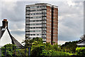
Moveen House, Finaghy, Belfast
One of two adjacent and identical tower blocks, in the Taughmonagh estate Image, built for the Northern Ireland Housing Trust in the early 1960’s. The view is from Orpen Park, Finaghy Road South. See also Image
Image: © Albert Bridge
Taken: 6 Jul 2011
0.10 miles
6
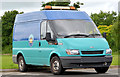
Ford Transit, Finaghy, Belfast
A Ford Transit van http://en.wikipedia.org/wiki/Ford_Transit , in Belfast City Council livery, parked at the Wedderburn Park playing fields.
Image: © Albert Bridge
Taken: 4 Jul 2013
0.11 miles
7
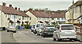
Garron Crescent, Finaghy, Belfast (April 2016)
Pre-1960 social housing – possibly built by the old Northern Ireland Housing Trust (further information welcome). This view is from Benmore Drive towards Locksley Park.
Image: © Albert Bridge
Taken: 13 Apr 2016
0.12 miles
8
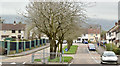
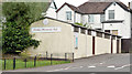
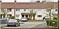
Benmore Drive, Finaghy, Belfast (April 2016)
Pre-1960 social housing sometimes associated with, but not part of, the Taughmonagh Estate. When built it was outside the Belfast Corporation boundary.
Image: © Albert Bridge
Taken: 13 Apr 2016
0.13 miles
9
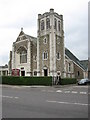
Lowe Memorial Presbyterian Church
Built in 1935 on the Upper Lisburn Road at Finaghy.
Image: © Brian Shaw
Taken: 18 Oct 2005
0.13 miles
10
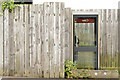
Doon End, Finaghy, Belfast (April 2016)
A cul-de-sac, with a hammerhead turning space, off Benmore Drive Image
Image: © Albert Bridge
Taken: 13 Apr 2016
0.14 miles