IMAGES TAKEN NEAR TO
Locksley Grange, BELFAST, BT10 0DW
Introduction
This page details the photographs taken nearby to Locksley Grange, BT10 0DW by members of the Geograph project.
The Geograph project started in 2005 with the aim of publishing, organising and preserving representative images for every square kilometre of Great Britain, Ireland and the Isle of Man.

There are currently over 7.5m images from over14,400 individuals and you can help contribute to the project by visiting https://www.geograph.org.uk
Image Map
Images are licensed for reuse under creativecommons.org/licenses/by-sa/2.0
Notes
- Clicking on the map will re-center to the selected point.
- The higher the marker number, the further away the image location is from the centre of the postcode.
Image Listing (25 Images Found)
Images are licensed for reuse under creativecommons.org/licenses/by-sa/2.0
Image
Details
Distance
1
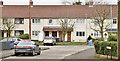
Benmore Drive, Finaghy, Belfast (April 2016)
Pre-1960 social housing sometimes associated with, but not part of, the Taughmonagh Estate. When built it was outside the Belfast Corporation boundary.
Image: © Albert Bridge
Taken: 13 Apr 2016
0.13 miles
2
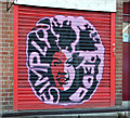
Decorated shutter door, Finaghy, Belfast
A decorated shutter door, on a hairdressing salon, on the Upper Lisburn Road.
Image: © Albert Bridge
Taken: 4 Aug 2013
0.14 miles
3
Doon End, Finaghy, Belfast (April 2016)
A cul-de-sac, with a hammerhead turning space, off Benmore Drive Image
Image: © Albert Bridge
Taken: 13 Apr 2016
0.14 miles
4
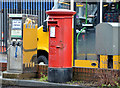
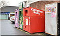
Pillar box and drop box, Finaghy, Belfast
Drop box and EIIR pillar box (BT10 459), at a petrol station/Eurospar/post office, at the corner of the Upper Lisburn Road and Diamond Gardens (background).
Image: © Albert Bridge
Taken: 17 Dec 2012
0.15 miles
5

ESSO tiger, Belfast
A homeless ESSO tiger on the canopy of a BP station, on the Upper Lisburn Road, at Finaghy. Esso withdrew from the NI retail market some years ago.
Image: © Albert Bridge
Taken: 11 Jul 2010
0.16 miles
6
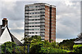
Moveen House, Finaghy, Belfast
One of two adjacent and identical tower blocks, in the Taughmonagh estate Image, built for the Northern Ireland Housing Trust in the early 1960’s. The view is from Orpen Park, Finaghy Road South. See also Image
Image: © Albert Bridge
Taken: 6 Jul 2011
0.16 miles
7
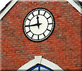
Bethany Church, Finaghy, Belfast (2)
See Image The clock – one minute fast.
Image: © Albert Bridge
Taken: 28 Jan 2010
0.16 miles
8
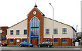
Bethany Church, Finaghy, Belfast
Evangelical church, on the Upper Lisburn Road, founded just before WWII. The present building dates from circa 1992/3. See also Image
Image: © Albert Bridge
Taken: 28 Jan 2010
0.16 miles
9
Recycling bins, Finaghy, Belfast
Recycling bins at the Upper Lisburn Road end of Mount Aboo Park. Work on the building of the street seems to have started in 1908. Before demolition and redevelopment it was the site of Aboo House once the home of Robert Spence, a retired surgeon who had served in the Indian army - see http://en.wikipedia.org/wiki/Mount_Abu.
Image: © Albert Bridge
Taken: 17 Dec 2012
0.16 miles
10
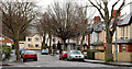
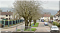
Marguerite Park, Belfast
Tree-lined street of semis, off the Upper Lisburn Road, at Finaghy.
Image: © Albert Bridge
Taken: 28 Jan 2010
0.17 miles