IMAGES TAKEN NEAR TO
Orpen Drive, BELFAST, BT10 0BT
Introduction
This page details the photographs taken nearby to Orpen Drive, BT10 0BT by members of the Geograph project.
The Geograph project started in 2005 with the aim of publishing, organising and preserving representative images for every square kilometre of Great Britain, Ireland and the Isle of Man.

There are currently over 7.5m images from over14,400 individuals and you can help contribute to the project by visiting https://www.geograph.org.uk
Image Map
Images are licensed for reuse under creativecommons.org/licenses/by-sa/2.0
Notes
- Clicking on the map will re-center to the selected point.
- The higher the marker number, the further away the image location is from the centre of the postcode.
Image Listing (23 Images Found)
Images are licensed for reuse under creativecommons.org/licenses/by-sa/2.0
Image
Details
Distance
1
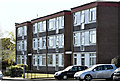
Orpen Drive, Finaghy, Belfast (April 2016)
There are several of these blocks of flats in the area between Finaghy Road South and the Upper Lisburn Road. To the best of my knowledge they were built in the 1960’s to a design which has lasted well.
Image: © Albert Bridge
Taken: 22 Apr 2016
0.10 miles
2

Ford Transit, Finaghy, Belfast
A Ford Transit van http://en.wikipedia.org/wiki/Ford_Transit , in Belfast City Council livery, parked at the Wedderburn Park playing fields.
Image: © Albert Bridge
Taken: 4 Jul 2013
0.11 miles
3
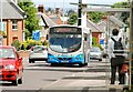
Bus, Finaghy, Belfast
A Wright-bodied Scania makes its way along the Upper Lisburn Road, at Finaghy, with the 12.10 service from Belfast (Upper Queen Street) Image to the Ballymacash estate, Lisburn.
Image: © Albert Bridge
Taken: 11 Jun 2009
0.11 miles
4
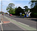
Upper Lisburn Road, Belfast
Looking back in the direction of central Belfast along the Upper Lisburn Road at Finaghy.
Image: © Rossographer
Taken: 6 May 2008
0.13 miles
5
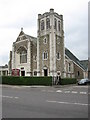
Lowe Memorial Presbyterian Church
Built in 1935 on the Upper Lisburn Road at Finaghy.
Image: © Brian Shaw
Taken: 18 Oct 2005
0.13 miles
6
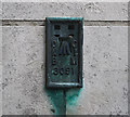
Flush Bracket, Belfast
Flush bracket on the south western tip (at the join with the new extension) of Lowe Memorial Presbyterian Church Image on the Upper Lisburn Road Belfast.
The number on the bracket is OSNIBM 3091.
The mark is 27.20 metres above MSL.
A flush bracket is a type of bench mark set onto the face of a building. See also http://www.geograph.org.uk/search.php?i=11037856 for many other examples I have found.
Image: © Rossographer
Taken: 21 Apr 2010
0.16 miles
7
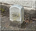
GPO cable marker post, Finaghy, Belfast (May 2016)
A GPO cable marker post, outside the boundary wall of Finaghy Health Centre, at Finaghy Road South. In better condition than most of the other surviving posts in NI.
Image: © Albert Bridge
Taken: 1 May 2016
0.16 miles
8
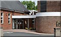
Finaghy Methodist church, Belfast (2)
Image: © Albert Bridge
Taken: 4 Jul 2013
0.17 miles
9
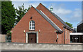
Finaghy Methodist church, Belfast (1)
Part of Finaghy Methodist church (right) and the church hall on the Upper Lisburn Road. I have not been able to discover when the congregation was formed or when the present church was built. Further information welcome. Image shows the church hall.
Image: © Albert Bridge
Taken: 4 Jul 2013
0.18 miles
10
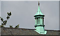
Finaghy Methodist church, Belfast (3)
See Image The lantern on the hall’s roof.
Image: © Albert Bridge
Taken: 4 Jul 2013
0.18 miles