IMAGES TAKEN NEAR TO
Sicily Park, BELFAST, BT10 0AQ
Introduction
This page details the photographs taken nearby to Sicily Park, BT10 0AQ by members of the Geograph project.
The Geograph project started in 2005 with the aim of publishing, organising and preserving representative images for every square kilometre of Great Britain, Ireland and the Isle of Man.

There are currently over 7.5m images from over14,400 individuals and you can help contribute to the project by visiting https://www.geograph.org.uk
Image Map
Images are licensed for reuse under creativecommons.org/licenses/by-sa/2.0
Notes
- Clicking on the map will re-center to the selected point.
- The higher the marker number, the further away the image location is from the centre of the postcode.
Image Listing (6 Images Found)
Images are licensed for reuse under creativecommons.org/licenses/by-sa/2.0
Image
Details
Distance
1
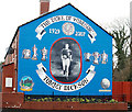
Tommy Dickson mural, Belfast
See Image Mural, in Taughmonagh, commemorating the Linfield footballer Tommy Dickson. Despite a prolific career in the Irish League he only ever won one cap - against Scotland in 1956. He was footballer of the year in the 1961/62 season. Continue to Image
Image: © Albert Bridge
Taken: 28 Jan 2010
0.10 miles
2
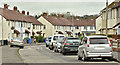
Garron Crescent, Finaghy, Belfast (April 2016)
Pre-1960 social housing – possibly built by the old Northern Ireland Housing Trust (further information welcome). This view is from Benmore Drive towards Locksley Park.
Image: © Albert Bridge
Taken: 13 Apr 2016
0.21 miles
3
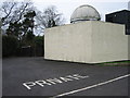
Observatory
This observatory is part of a private house in south Belfast: it must have been purpose-built.
Image: © Brian Shaw
Taken: 22 Dec 2005
0.21 miles
4
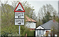
Road humps sign, Finaghy, Belfast (April 2016)
Traffic-calming road “humps” sign at the Sicily Park end of Locksley Gardens – widespread in suburban Belfast.
Image: © Albert Bridge
Taken: 13 Apr 2016
0.22 miles
5
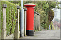
Pillar box (BT10 492), Finaghy, Belfast (April 2016)
GR pillar box (BT10 492) at the Locksley Park/Locksley Gardens crossroads.
Image: © Albert Bridge
Taken: 13 Apr 2016
0.22 miles
6

The Upper Malone Road, Belfast
See Image Part of the back road between Belfast and Lisburn/Dunmurry, this twisting stretch is still in suburban Belfast. The view is towards Lisburn from Linkview Park.
Image: © Albert Bridge
Taken: 1 Aug 2009
0.24 miles