IMAGES TAKEN NEAR TO
Walliscote Road, BRISTOL, BS9 4RZ
Introduction
This page details the photographs taken nearby to Walliscote Road, BS9 4RZ by members of the Geograph project.
The Geograph project started in 2005 with the aim of publishing, organising and preserving representative images for every square kilometre of Great Britain, Ireland and the Isle of Man.

There are currently over 7.5m images from over14,400 individuals and you can help contribute to the project by visiting https://www.geograph.org.uk
Image Map
Images are licensed for reuse under creativecommons.org/licenses/by-sa/2.0
Notes
- Clicking on the map will re-center to the selected point.
- The higher the marker number, the further away the image location is from the centre of the postcode.
Image Listing (35 Images Found)
Images are licensed for reuse under creativecommons.org/licenses/by-sa/2.0
Image
Details
Distance
1
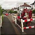
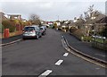
Roadworks, Hill View
Cutting Hill View in half, as far as the motorist in concerned. Someone over the road is having their roof done.
Image: © Derek Harper
Taken: 4 Aug 2013
0.10 miles
2
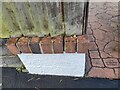
Ordnance Survey Cut Mark
This OS cut mark can be found on the wall of Nos 52 & 54 The Crescent. It marks a point 82.060m above mean sea level.
Image: © Adrian Dust
Taken: 15 Jul 2023
0.12 miles
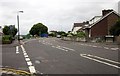
3
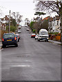
Henleaze Park Drive
Typical hilly road in Henleaze.
Image: © Linda Bailey
Taken: 16 Jan 2006
0.13 miles
4
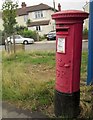
Postbox, Hill View
A George V postbox, BS9 315, on a little triangle of grass at the junction with Park Grove.
Image: © Derek Harper
Taken: 4 Aug 2013
0.15 miles
5
St Margaret's Drive, Henleaze, Bristol
Viewed from the corner of Henleaze Park, opposite Claremont School. http://www.geograph.org.uk/photo/3330866
Image: © Jaggery
Taken: 30 Jan 2013
0.16 miles
6
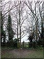
Access point to a footpath
The footpath runs along the edge of a sports field, and access to it is immediately behind the tree, by about 2 feet.
Image: © Linda Bailey
Taken: 25 Dec 2006
0.17 miles
7
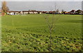
Golden Hill Sports Ground, Bristol
Viewed from a footpath at the edge of Henleaze Park.
Image: © Jaggery
Taken: 30 Jan 2013
0.17 miles
8
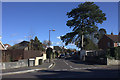
Junctions on Park Grove, Bristol
With The Drive on the left, Henleaze Park on the right, and Hill View taking over as the main road as it forks to the right.
Image: © Derek Harper
Taken: 4 Aug 2013
0.18 miles
10
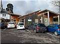
The Wooden Spoon Building, Henleaze, Bristol
This building was officially opened on January 16th 2009 by HRH The Princess Royal, who is Patron of the Wooden Spoon Society, which had donated £135,000 for the new timber framed building.
It contains a main room, a children's play area, two offices, a reception area and a kitchen.
The Paediatric Communication Aids Service (PCAS), a regional communication aids service in Bristol, is based in this building inside the Claremont School site. http://www.geograph.org.uk/photo/3330866 PCAS was launched more than a decade ago to provide an assessment and training service for children with severe communication difficulties, and their carers both at home and school. The age group is 1-14 and referrals come from a wide area of SW England. The children have significant communication difficulties because of cerebral palsy, learning disabilities, autism or other disorders of speech and language development.
Image: © Jaggery
Taken: 30 Jan 2013
0.19 miles