IMAGES TAKEN NEAR TO
Wyecliffe Road, BRISTOL, BS9 4NH
Introduction
This page details the photographs taken nearby to Wyecliffe Road, BS9 4NH by members of the Geograph project.
The Geograph project started in 2005 with the aim of publishing, organising and preserving representative images for every square kilometre of Great Britain, Ireland and the Isle of Man.

There are currently over 7.5m images from over14,400 individuals and you can help contribute to the project by visiting https://www.geograph.org.uk
Image Map
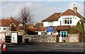
Images are licensed for reuse under creativecommons.org/licenses/by-sa/2.0
Notes
- Clicking on the map will re-center to the selected point.
- The higher the marker number, the further away the image location is from the centre of the postcode.
Image Listing (65 Images Found)
Images are licensed for reuse under creativecommons.org/licenses/by-sa/2.0
Image
Details
Distance
1
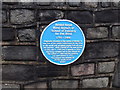
Blue Plaque,Henleaze Road
Commemorating the site of the School of Industry for the Blind.
Image: © Eirian Evans
Taken: 15 Oct 2014
0.03 miles
2
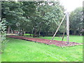
Park and playing field on Henleaze Road
Image: © Eirian Evans
Taken: 30 Sep 2010
0.05 miles
3
Broadleys Avenue, Bristol
Viewed from the corner of Southmead Road. The street name sign shows LEADING TO HOBHOUSE CLOSE. Most street name signs in Bristol include the postal district, such as BS9. This sign is an exception.
Image: © Jaggery
Taken: 30 Jan 2013
0.05 miles
4
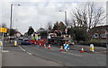
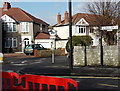
Southmead Road roadworks, Bristol
Opposite Lake Road.
Image: © Jaggery
Taken: 30 Jan 2013
0.05 miles
5
An old-style distance sign, Southmead Road, Bristol
The sign near the corner of Lake Road points along the B4056 Southmead Road towards Gloucester (33½ miles).
Image: © Jaggery
Taken: 30 Jan 2013
0.06 miles
6
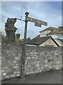
Direction Sign ? Signpost on Southmead Road, Bristol
Located on the northeast side of the junction of the B4056 Southmead Road and Lake Road in Henleaze, Bristol. 2 arms, 1 missing and lost finial. See also https://www.geograph.org.uk/photo/3330624.
Milestone Society National ID: GL_ST5877
Image: © S Kosciow
Taken: 22 Oct 2022
0.06 miles
7
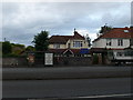
Lake House Day Nursery
A children's nursery on Southmead Road.
Image: © Eirian Evans
Taken: 30 Sep 2010
0.06 miles
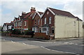
8
Henleaze Terrace, Bristol
Viewed from Eastfield Road. The name sign shows that Henleaze Terrace is a private road and a no through road.
Image: © Jaggery
Taken: 30 Jan 2013
0.07 miles
9
Lake House Day Nursery, Bristol
This is the Southmead Road side of the nursery. The main entrance is around the corner in Lake Road.
Image: © Jaggery
Taken: 30 Jan 2013
0.07 miles
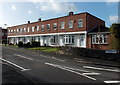
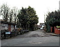
10
Eastfield Road houses near the corner of Cheriton Place, Bristol
Image: © Jaggery
Taken: 30 Jan 2013
0.08 miles