IMAGES TAKEN NEAR TO
Priory Court Road, BRISTOL, BS9 4DB
Introduction
This page details the photographs taken nearby to Priory Court Road, BS9 4DB by members of the Geograph project.
The Geograph project started in 2005 with the aim of publishing, organising and preserving representative images for every square kilometre of Great Britain, Ireland and the Isle of Man.

There are currently over 7.5m images from over14,400 individuals and you can help contribute to the project by visiting https://www.geograph.org.uk
Image Map
Images are licensed for reuse under creativecommons.org/licenses/by-sa/2.0
Notes
- Clicking on the map will re-center to the selected point.
- The higher the marker number, the further away the image location is from the centre of the postcode.
Image Listing (119 Images Found)
Images are licensed for reuse under creativecommons.org/licenses/by-sa/2.0
Image
Details
Distance
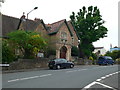
1
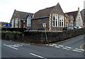
Community Church in Westbury-on-Trym
On the corner of Albert Place and Eastfield Road.
Image: © Jaggery
Taken: 29 Oct 2012
0.03 miles
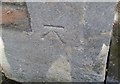
2
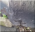
Ordnance Survey Cut Mark
This OS cut mark can be found on No60 Chock Lane. It marks a point 48.442m above mean sea level.
Image: © Adrian Dust
Taken: 17 Jan 2020
0.04 miles
3
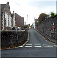
Albert Place, Westbury-on-Trym
A 90 metre long cul-de-sac viewed from Eastfield Road. The Community Church http://www.geograph.org.uk/photo/3721753 is on the left.
Image: © Jaggery
Taken: 29 Oct 2012
0.05 miles
4
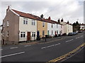
Eastfield Road houses, Westbury-On-Trym, Bristol
Viewed from opposite Chock Lane.
Image: © Jaggery
Taken: 30 Jan 2013
0.05 miles
5
Ordnance Survey Cut Mark
This OS cut mark can be found on the Village Hall, Eastfield Road. It marks a point 52.922m above mean sea level.
Image: © Adrian Dust
Taken: 17 Jan 2020
0.06 miles
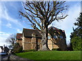
6
Westbury on Trym Village Hall
Near the junction of Water's Lane and Eastfield Road.
Image: © Eirian Evans
Taken: 20 May 2012
0.06 miles
7
Westbury-on-Trym Village Hall
Near the junction of Water's Lane and Eastfield Road.
Image: © Eirian Evans
Taken: 3 Feb 2016
0.07 miles
8
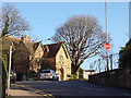
Westbury-on-Trym Village Hall
The village hall is on Eastfield Road, just beyond the top of Waters Lane.
Image: © Linda Bailey
Taken: 11 Jan 2006
0.07 miles
9
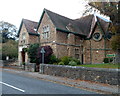
Village Hall, Westbury-on-Trym
Viewed across Eastfield Road. The year 1869 is inscribed above the doorway. The hall was financed by local benefactor Henry St Vincent Ames for the promotion of recreation and social & moral improvement by means of lectures, music, reading, exhibitions of art, science, industry, agriculture, horticulture and public instruction. After his death in 1901, the hall was given to the village.
Mains gas and water were installed in 1902, electricity in 1926.
Image: © Jaggery
Taken: 29 Oct 2012
0.07 miles
10
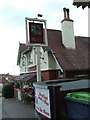
The Mouse public house, Westbury on Trym
One of Westbury's cosier establishments.
Image: © C P Smith
Taken: 12 Aug 2010
0.07 miles