IMAGES TAKEN NEAR TO
Grange Close North, BRISTOL, BS9 4BY
Introduction
This page details the photographs taken nearby to Grange Close North, BS9 4BY by members of the Geograph project.
The Geograph project started in 2005 with the aim of publishing, organising and preserving representative images for every square kilometre of Great Britain, Ireland and the Isle of Man.

There are currently over 7.5m images from over14,400 individuals and you can help contribute to the project by visiting https://www.geograph.org.uk
Image Map
Images are licensed for reuse under creativecommons.org/licenses/by-sa/2.0
Notes
- Clicking on the map will re-center to the selected point.
- The higher the marker number, the further away the image location is from the centre of the postcode.
Image Listing (54 Images Found)
Images are licensed for reuse under creativecommons.org/licenses/by-sa/2.0
Image
Details
Distance
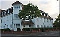
1
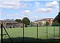
The Red Maids' School
An independent girls' school located on Westbury Road.
Image: © Colin Bews
Taken: 26 Jul 2011
0.10 miles
2
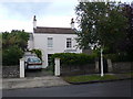
Arbutus Cottage
Cottage on Eastfield, Bristol. Arbutus is also known as "strawberry tree".
Image: © Eirian Evans
Taken: 30 Sep 2010
0.11 miles
3
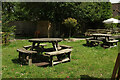
Garden, Eastfield Inn
Outdoor tables in the pub garden.
Image: © Derek Harper
Taken: 28 May 2022
0.15 miles
4
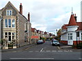
Grange Court Road, Westbury on Trym, Bristol
Viewed across Westbury Road. Majestic wine warehouse http://www.geograph.org.uk/photo/3207543 is on the right.
Image: © Jaggery
Taken: 29 Oct 2012
0.15 miles
5
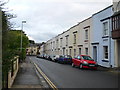
Eastfield Terrace
A Victorian residential terrace in Henleaze.
Image: © Eirian Evans
Taken: 30 Sep 2010
0.16 miles
7
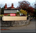
Lodge at an entrance to Red Maids' School, Westbury on Trym, Bristol
In front of the black-and-white lodge, a faint inscription on a block shows
The Red Maids' School 1634.
Image: © Jaggery
Taken: 29 Oct 2012
0.17 miles
9
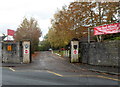
An entrance to The Red Maids' School, Westbury on Trym, Bristol
An entrance and exit for pedestrians, but now only an exit for vehicles. Viewed across Westbury Road. A plaque http://www.geograph.org.uk/photo/3207761 on the right gate pillar shows that the gates were presented to the school in 1934 on the 300th anniversary of its foundation by the Old Girls Society.
Image: © Jaggery
Taken: 29 Oct 2012
0.18 miles
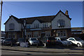
10
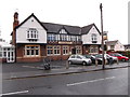
The Eastfield Inn
On Henleaze Road, Bristol.
Image: © Eirian Evans
Taken: 15 Oct 2014
0.18 miles