IMAGES TAKEN NEAR TO
Cote Lane, BRISTOL, BS9 3TW
Introduction
This page details the photographs taken nearby to Cote Lane, BS9 3TW by members of the Geograph project.
The Geograph project started in 2005 with the aim of publishing, organising and preserving representative images for every square kilometre of Great Britain, Ireland and the Isle of Man.

There are currently over 7.5m images from over14,400 individuals and you can help contribute to the project by visiting https://www.geograph.org.uk
Image Map
Images are licensed for reuse under creativecommons.org/licenses/by-sa/2.0
Notes
- Clicking on the map will re-center to the selected point.
- The higher the marker number, the further away the image location is from the centre of the postcode.
Image Listing (53 Images Found)
Images are licensed for reuse under creativecommons.org/licenses/by-sa/2.0
Image
Details
Distance
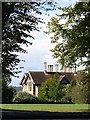
1
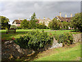
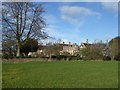
Oatley House Ha-Ha
Oakley House shown with its ha-ha where it meets Durdham Downs. The Downs were grazed by sheep in the past, it had been declining in the 19th century although it continued to 1925. The commoners still exercise their right to graze sheep on the Downs one day a year.
Image: © Linda Bailey
Taken: 2 Oct 2006
0.05 miles
2
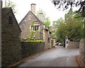
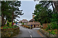
Cote Lane, Bristol
The buildings are part of St Monica Trust's Cote Lane Retirement Village. The building on the left is Gate Lodge.
Image: © Derek Harper
Taken: 29 May 2013
0.06 miles
3
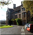
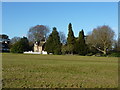
Oatley House, Westbury on Trym, Bristol
Grade II listed Oatley House is part of the St Monica Trust Cote Lane Retirement Village.
St Monica Trust retirement villages offer a range of sheltered accommodation,
nursing care homes and dementia care homes.
Image: © Jaggery
Taken: 29 Oct 2012
0.06 miles
4

Redland : Chaplain's Gate
Looking towards St Monica's Court.
Image: © Lewis Clarke
Taken: 8 Sep 2020
0.08 miles
5
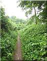
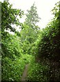
Footpath near Elmlea schools
I'm trying, unsuccessfully, to shelter under a tree beside public footpath BCC/118/20 during a prolonged downpour.
Image: © Derek Harper
Taken: 29 May 2013
0.09 miles
6
Footpath near Elmlea schools
Looking in the other direction along footpath BCC/118/20 to Image] from my inadequate shelter beneath a tree.
Image: © Derek Harper
Taken: 29 May 2013
0.09 miles
7
St Monica's Rest Home
At the northern end of the Downs, this Grade II listed mansion named after Monica Wills, wife of HH Wills, built as the largest of Bristol's almshouse foundations. It was built in late C19 Domestic Revival and Perpendicular Revival style and has extensive gardens enclosed by a ha-ha.
Image: © Eirian Evans
Taken: 3 Feb 2016
0.09 miles
8
Lodge at north end of Durdham Down, Bristol
Image: © Peter Barr
Taken: 10 Feb 2010
0.10 miles
9
Redland : Saint Augustine's Gate
Looking along Saint Augustine's Gate off Cote Lane.
Image: © Lewis Clarke
Taken: 8 Sep 2020
0.10 miles
10
Oatley House
Apartments run by the St Monica Trust to provide sheltered accommodation for the elderly. Built by Sir G. Oatley for HH Wills and Monica Wills, the trust is named after Monica Wills, and was the last of the city's almshouses. Viewed from the Westbury Road.
Image: © Linda Bailey
Taken: 2 Oct 2006
0.11 miles