IMAGES TAKEN NEAR TO
Barley Croft, BRISTOL, BS9 3TF
Introduction
This page details the photographs taken nearby to Barley Croft, BS9 3TF by members of the Geograph project.
The Geograph project started in 2005 with the aim of publishing, organising and preserving representative images for every square kilometre of Great Britain, Ireland and the Isle of Man.

There are currently over 7.5m images from over14,400 individuals and you can help contribute to the project by visiting https://www.geograph.org.uk
Image Map
Images are licensed for reuse under creativecommons.org/licenses/by-sa/2.0
Notes
- Clicking on the map will re-center to the selected point.
- The higher the marker number, the further away the image location is from the centre of the postcode.
Image Listing (20 Images Found)
Images are licensed for reuse under creativecommons.org/licenses/by-sa/2.0
Image
Details
Distance
1
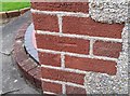
Ordnance Survey Cut Mark
This OS cut mark can be found on No65 Reeley Road. It marks a point 40.910m above mean sea level.
Image: © Adrian Dust
Taken: 17 Jan 2020
0.03 miles
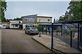
2
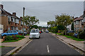
Redland : Barley Croft
Looking along Barley Croft from Brainsfield.
Image: © Lewis Clarke
Taken: 8 Sep 2020
0.04 miles
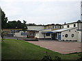
3
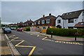
Redland : Brainsfield
Looking along a residential road.
Image: © Lewis Clarke
Taken: 8 Sep 2020
0.08 miles
4
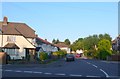
Oakhurst Rd, Bristol
Oakhurst Rd is a quiet residential street on the north side of Bristol just off Reedley Rd between Stoke Bishop and Westbury on Trym
Image: © Nigel Mykura
Taken: 24 May 2010
0.08 miles
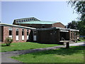
5
Redland : Elmlea Junior School
Elmlea Junior School converted to become an academy school in July 2011. It was rated outstanding by Ofsted.
Image: © Lewis Clarke
Taken: 8 Sep 2020
0.10 miles
6
Westbury-on-Trym, Bristol, Baptist Church
In Reedley Road.
Image: © ChurchCrawler
Taken: 19 May 2004
0.10 miles
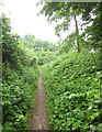
8
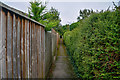
Redland : Footpath
A path between Reedley Road and Stoke Lane.
Image: © Lewis Clarke
Taken: 8 Sep 2020
0.13 miles
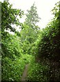
9
Footpath near Elmlea schools
I'm trying, unsuccessfully, to shelter under a tree beside public footpath BCC/118/20 during a prolonged downpour.
Image: © Derek Harper
Taken: 29 May 2013
0.14 miles
10
Footpath near Elmlea schools
Looking in the other direction along footpath BCC/118/20 to Image] from my inadequate shelter beneath a tree.
Image: © Derek Harper
Taken: 29 May 2013
0.14 miles