IMAGES TAKEN NEAR TO
Stoke Lane, BRISTOL, BS9 3SN
Introduction
This page details the photographs taken nearby to Stoke Lane, BS9 3SN by members of the Geograph project.
The Geograph project started in 2005 with the aim of publishing, organising and preserving representative images for every square kilometre of Great Britain, Ireland and the Isle of Man.

There are currently over 7.5m images from over14,400 individuals and you can help contribute to the project by visiting https://www.geograph.org.uk
Image Map
Images are licensed for reuse under creativecommons.org/licenses/by-sa/2.0
Notes
- Clicking on the map will re-center to the selected point.
- The higher the marker number, the further away the image location is from the centre of the postcode.
Image Listing (48 Images Found)
Images are licensed for reuse under creativecommons.org/licenses/by-sa/2.0
Image
Details
Distance
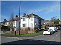
1
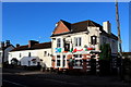
Prince of Wales, Westbury-on-Trym
Public House on Stoke Lane, Westbury, Bristol - tenanted out by Butcombe Brewery.
Image: © Chris Heaton
Taken: 10 Feb 2016
0.03 miles
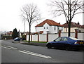
2
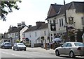
Choice of Pubs
On Stoke Lane "The Prince of Wales" and "The Black Swan" are not far away from each other!
Image: © Colin Bews
Taken: 26 Jul 2011
0.04 miles
4
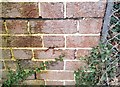
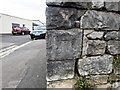
Ordnance Survey Cut Mark
This OS cut mark can be found on the NE angle of the Library. It marks a point 28.499m above mean sea level.
Image: © Adrian Dust
Taken: 17 Jan 2020
0.07 miles
5
The junction of Downs Cote Park with Falcondale Road, Westbury-on-Trym, Bristol
This is the north-western of the two junctions of these roads. See Image for the other one. The view was taken from the T7 bus that runs between Bristol and Chepstow.
Image: © Ruth Sharville
Taken: 14 Mar 2023
0.08 miles
6
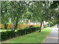
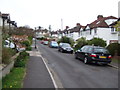
Falcondale Road
The attractive margin of a busy road.
Image: © don cload
Taken: 31 Jul 2011
0.09 miles
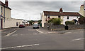
7
Junction of Falcondale Road and Stoke Lane, Redland
Image: © Roger Cornfoot
Taken: 18 Feb 2011
0.10 miles
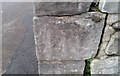
8
Unclear benchmark on wall
The OS description is WALL JUNC NO 122 STOKE LANE, and the mark, rather worn, is on the 4th stone up Image
Image: © Neville Goodman
Taken: 11 Jun 2017
0.10 miles
9
A worn benchmark
You'd have be looking out for this one Image I knew where it was from the OS description, but you'd want the light to be right to spot it otherwise.
Image: © Neville Goodman
Taken: 11 Jun 2017
0.10 miles
10
Ordnance Survey Cut Mark
This OS cut mark can be found on No122 Stoke Lane. It marks a point 33.967m above mean sea level.
Image: © Adrian Dust
Taken: 17 Jan 2020
0.10 miles