IMAGES TAKEN NEAR TO
Whytes Close, BRISTOL, BS9 3HU
Introduction
This page details the photographs taken nearby to Whytes Close, BS9 3HU by members of the Geograph project.
The Geograph project started in 2005 with the aim of publishing, organising and preserving representative images for every square kilometre of Great Britain, Ireland and the Isle of Man.

There are currently over 7.5m images from over14,400 individuals and you can help contribute to the project by visiting https://www.geograph.org.uk
Image Map
Images are licensed for reuse under creativecommons.org/licenses/by-sa/2.0
Notes
- Clicking on the map will re-center to the selected point.
- The higher the marker number, the further away the image location is from the centre of the postcode.
Image Listing (134 Images Found)
Images are licensed for reuse under creativecommons.org/licenses/by-sa/2.0
Image
Details
Distance
1
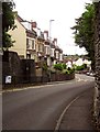
Terrace, Westbury-on-Trym
On Passage Road as it descends into the centre.
Image: © Derek Harper
Taken: 4 Aug 2013
0.04 miles
2
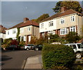
Walton Rise, Westbury-on-Trym, Bristol
Houses in a cul-de-sac on the north side of Trym Road.
Image: © Jaggery
Taken: 29 Oct 2012
0.08 miles
3
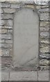
Old Milestone by Passage Road, Westbury on Trym, Bristol Parish
Carved stone post by the UC road, in parish of BRISTOL (CITY OF BRISTOL District), Westbury on Trym, outside No. 9 Passage Road, set into stone wall of house, on North side of road. Erected by the Aust Division turnpike trust in the 18th century.
Inscription reads:- : To / the Standard / at the top / of Park Street / 3 / miles :
Milestone Society National ID: GL_BRPG03.
Image: © A Rosevear
Taken: 2 Apr 2003
0.08 miles
4
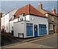
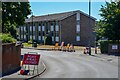
SureCare, Westbury on Trym, Bristol
Office on the corner of Passage Road and Watkins Yard.
SureCare began as an alarm business. It expanded into domiciliary care in 1996. It is now part of Housing 21, a social enterprise providing homes and services to enable people to have a good later life.
Image: © Jaggery
Taken: 29 Oct 2012
0.09 miles
5
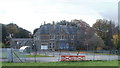
Elmfield School for Deaf Children, Bristol
The school is located in Elmfield House, on the SE side of Greystoke Avenue.
Image: © Jaggery
Taken: 6 Nov 2010
0.10 miles
6
Bristol : Passage Avenue
Off Greystoke Avenue.
Image: © Lewis Clarke
Taken: 10 Aug 2022
0.10 miles
7
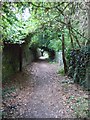
A footpath to Westbury Village
This path goes from the playing field linked to Badock's Wood to the centre of Westbury village.
Image: © C P Smith
Taken: 12 Aug 2010
0.10 miles

9
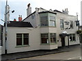
White Lion, Westbury on Trym, Bristol
Pub on the corner of Passage Road and Trym Road, facing the NE end of High Street.
Image: © Jaggery
Taken: 29 Oct 2012
0.10 miles
10

The remains of Westbury College, Westbury on Trym, Bristol
Westbury College was originally set up to house a body of priests who served the then collegiate Holy Trinity Church nearby. The college was built in the mid 15th century by John Carpenter, a local lad who rose to become Bishop of Worcester, and who planned to establish a new cathedral in Westbury near to the commercial centre of his diocese - Bristol. He styled himself Bishop of Worcester and Westbury! Had he lived rather longer, Westbury might now boast a great perpendicular gothic cathedral! William Canynge, the famous Bristol merchant and funder of the building of St Mary Redcliffe, was Dean here after his wife died and he joined the priesthood.
Image: © C P Smith
Taken: 12 Aug 2010
0.10 miles