IMAGES TAKEN NEAR TO
Westfield Road, BRISTOL, BS9 3HG
Introduction
This page details the photographs taken nearby to Westfield Road, BS9 3HG by members of the Geograph project.
The Geograph project started in 2005 with the aim of publishing, organising and preserving representative images for every square kilometre of Great Britain, Ireland and the Isle of Man.

There are currently over 7.5m images from over14,400 individuals and you can help contribute to the project by visiting https://www.geograph.org.uk
Image Map
Images are licensed for reuse under creativecommons.org/licenses/by-sa/2.0
Notes
- Clicking on the map will re-center to the selected point.
- The higher the marker number, the further away the image location is from the centre of the postcode.
Image Listing (144 Images Found)
Images are licensed for reuse under creativecommons.org/licenses/by-sa/2.0
Image
Details
Distance
1
Fraley Road, Westbury-on-Trym, Bristol
Fraley Road is a 90 metre long cul-de-sac on the north side of Westbury Court Road.
Flats in Carlton House are behind the trees.
Image: © Jaggery
Taken: 29 Oct 2012
0.05 miles
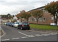
2

Houses in Falcondale Road, Westbury-on-Trym, Bristol
Some upgraded "prefab" bungalows can be seen in this shot.
Image: © Ruth Sharville
Taken: 18 Mar 2011
0.05 miles
3
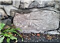
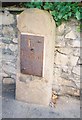
Ordnance Survey Cut Mark
This OS cut mark can be found on the wall of No20 Henbury Road. It marks a point 30.602m above mean sea level.
Image: © Adrian Dust
Taken: 1 Nov 2021
0.06 miles
4
Old-style signpost in Westbury-on-Trym, Bristol
Located at the junction of High Street, Henbury Road and Passage Road.
Rombourne executive serviced offices are in the background.
Image: © Jaggery
Taken: 29 Oct 2012
0.07 miles
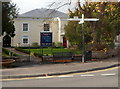
5
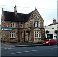
Police Station
Originally Westbury Police Station, now a solicitors office.
Image: © don cload
Taken: 31 Jul 2011
0.07 miles
6
Old Milestone by the B4055, Henbury Road
Bristol incised iron plate by the UC road, in parish of Bristol (City of Bristol District), Henbury Road, Westbury on Trym, 50m from junction, by Trym Lodge, in pavement, with back to stone garden wall with laurel hedge, between drive and lamppost. 'Lost' after October 2009.
Inscription reads:-
To
Briftol
3
Grade II listed.
List Entry Number: 1282259 https://historicengland.org.uk/listing/the-list/list-entry/1282259
Surveyed
Milestone Society National ID: GL_brhb03
Image: © Milestone Society
Taken: Unknown
0.07 miles
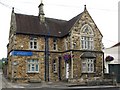
7
Lyons solicitors' office, Westbury-on-Trym, Bristol
The office is at 49 High Street. The small white building on the right is The Laundry Basket.
Image: © Jaggery
Taken: 29 Oct 2012
0.07 miles
8
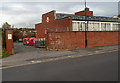
Entrance to Royal Mail delivery office, Westbury-on-Trym, Bristol
Viewed across Westbury Court Road. The delivery office (formerly known as the sorting office) adjoins the post office. http://www.geograph.org.uk/photo/3208158
Image: © Jaggery
Taken: 29 Oct 2012
0.08 miles
9
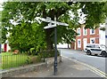
Westbury-on-Trym, fingerpost
A well-maintained post at the junction of High Street and Henbury Road.
Image: © Mike Faherty
Taken: 20 Jul 2011
0.08 miles
10
Westbury-on-Trym High Street
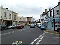
With a refreshingly high proportion of small businesses.
Image: © Mike Faherty
Taken: 20 Jul 2011
0.08 miles