IMAGES TAKEN NEAR TO
Stoke Lane, BRISTOL, BS9 3DN
Introduction
This page details the photographs taken nearby to Stoke Lane, BS9 3DN by members of the Geograph project.
The Geograph project started in 2005 with the aim of publishing, organising and preserving representative images for every square kilometre of Great Britain, Ireland and the Isle of Man.

There are currently over 7.5m images from over14,400 individuals and you can help contribute to the project by visiting https://www.geograph.org.uk
Image Map
Images are licensed for reuse under creativecommons.org/licenses/by-sa/2.0
Notes
- Clicking on the map will re-center to the selected point.
- The higher the marker number, the further away the image location is from the centre of the postcode.
Image Listing (137 Images Found)
Images are licensed for reuse under creativecommons.org/licenses/by-sa/2.0
Image
Details
Distance
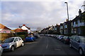
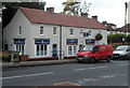
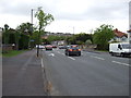
2
Falcondale Road
Looking north up Falcondale Road close to the junction with Stoke Lane. Falcondale is part of the A4018 running north from Bristol towards the M5 at Cribbs Causeway.
Image: © Nigel Mykura
Taken: 24 May 2010
0.06 miles
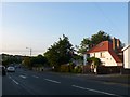
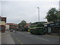
3
Canford Lane, Looking West
Canford Lane looking west, with Bristol RE bus heading into the city centre on a vintage running day. The entrance to a shopping precinct is on the right.
Image: © David Roberts
Taken: 15 May 2010
0.06 miles
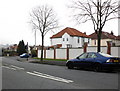
4
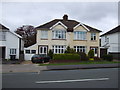
Houses on Falcondale Road, Westbury-on-Trym
Image: © JThomas
Taken: 10 May 2013
0.07 miles
5
Premier Homecare office, Westbury-on-Trym, Bristol
Viewed across Canford Lane. Premier Homecare is an independently-owned provider of private home care and domiciliary care services.
Image: © Jaggery
Taken: 29 Oct 2012
0.07 miles
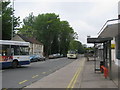
6
Canford Lane, Looking East
Canford Lane, looking east on a quiet Sunday. The Bristol Lodekka bus outside the shops is making its first public appearance since restoration.
Image: © David Roberts
Taken: 15 May 2010
0.08 miles
7
Junction of Falcondale Road and Stoke Lane, Redland
Image: © Roger Cornfoot
Taken: 18 Feb 2011
0.08 miles
8

Ordnance Survey Cut Mark
This OS cut mark can be found on the Club, SW side of Stoke Lane. It marks a point 33.924m above mean sea level.
Image: © Adrian Dust
Taken: 17 Jan 2020
0.08 miles
9
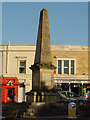
Westbury-on-Trym War Memorial
The War Memorial is in the centre of the village.
Image: © Linda Bailey
Taken: 11 Jan 2006
0.09 miles
10
Falcondale Road, Westbury-on-Trym
Heading north.
Image: © JThomas
Taken: 10 May 2013
0.09 miles