IMAGES TAKEN NEAR TO
East Parade, BRISTOL, BS9 2JW
Introduction
This page details the photographs taken nearby to East Parade, BS9 2JW by members of the Geograph project.
The Geograph project started in 2005 with the aim of publishing, organising and preserving representative images for every square kilometre of Great Britain, Ireland and the Isle of Man.

There are currently over 7.5m images from over14,400 individuals and you can help contribute to the project by visiting https://www.geograph.org.uk
Image Map
Images are licensed for reuse under creativecommons.org/licenses/by-sa/2.0
Notes
- Clicking on the map will re-center to the selected point.
- The higher the marker number, the further away the image location is from the centre of the postcode.
Image Listing (43 Images Found)
Images are licensed for reuse under creativecommons.org/licenses/by-sa/2.0
Image
Details
Distance
1
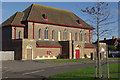
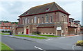
Sea Mills Methodist Church
Contemporary with the surrounding inter-war 'garden suburb', this substantial church was built in an era when the provision of facilities for worship were considered an essential element of any housing development - well before pubs and even shops.
Image: © Stephen McKay
Taken: 10 Nov 2010
0.02 miles
2
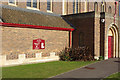
Sea Mills Methodist Church
Showing detail of this large church on Shirehampton Road; see Image for a wider view.
Image: © Stephen McKay
Taken: 10 Nov 2010
0.02 miles
3
Sea Mills Methodist Church and Abona Court
Image: © Roger Cornfoot
Taken: 7 Oct 2020
0.03 miles
4
East Parade, Sea Mills, Bristol
Viewed from the Shirehampton Road end.
Image: © Jaggery
Taken: 23 Jun 2012
0.06 miles
5
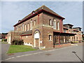
Sea Mills Methodist Church and Abona Court, Bristol
Located on the north side of Shirehampton Road between West Parade and East Parade, Sea Mills Methodist Church dates from 1930. Abona Court, part of which can be seen on the right, opened in 2007. There are 21 one- and two-bedroom apartments. Abona Court also has a conservatory, communal lounge, guest room and a lift. The apartments adjoin the church hall on the eastern edge of the church. Abona Court was developed by MHA (a provider of not-for-profit care homes, housing and support services for older people) in association with the church.
Image: © Jaggery
Taken: 23 Jun 2012
0.06 miles
6
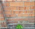
Ordnance Survey Cut Mark
This OS cut mark can be found on No130 Shirehampton Road. It marks a point 28.761m above mean sea level.
Image: © Adrian Dust
Taken: 8 Oct 2021
0.06 miles
7
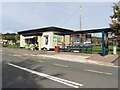
Cafe and bus stop on Shirehampton Road
Image: © Roger Cornfoot
Taken: 7 Oct 2020
0.06 miles
8
SE side of The Crescent, Sea Mills, Bristol
The Crescent is a semicircular road on the north side Shirehampton Road. The two arms of The Crescent join Shirehampton Road about 300 metres apart.
Image: © Jaggery
Taken: 23 Jun 2012
0.09 miles
9
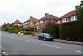
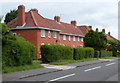
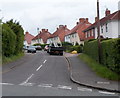
Shirehampton Road houses, Sea Mills, Bristol
Viewed from the corner of Meadway. http://www.geograph.org.uk/photo/3029440
Image: © Jaggery
Taken: 23 Jun 2012
0.09 miles
10
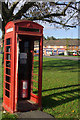
Telephone box in Sea Mills
This K6 telephone box is in a sorry state with no glass and its door missing.
Image: © Stephen McKay
Taken: 10 Nov 2010
0.09 miles