IMAGES TAKEN NEAR TO
Avonleaze, BRISTOL, BS9 2HU
Introduction
This page details the photographs taken nearby to Avonleaze, BS9 2HU by members of the Geograph project.
The Geograph project started in 2005 with the aim of publishing, organising and preserving representative images for every square kilometre of Great Britain, Ireland and the Isle of Man.

There are currently over 7.5m images from over14,400 individuals and you can help contribute to the project by visiting https://www.geograph.org.uk
Image Map
Images are licensed for reuse under creativecommons.org/licenses/by-sa/2.0
Notes
- Clicking on the map will re-center to the selected point.
- The higher the marker number, the further away the image location is from the centre of the postcode.
Image Listing (64 Images Found)
Images are licensed for reuse under creativecommons.org/licenses/by-sa/2.0
Image
Details
Distance
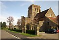
1

St Edyth's Church
An Evangelical Anglican church, St Edyth's Church dates from 1924 and was so dedicated in honour of Lady Edyth Lennard, the wife of the Lord of the Manor who gave the land for the building of the church.
Image: © Eirian Evans
Taken: 19 Sep 2017
0.03 miles
2
St Edyth?s Church, Sea Mills
Another view of Image], this time across Avonleaze, and from the Community Forest Path.
Image: © Derek Harper
Taken: 29 Mar 2014
0.03 miles
3
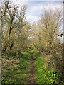
Path, Three Acre Covert
Footpath BCC/74/10, running along the eastern edge of the wood, is followed by the Forest of Avon Community Forest Path.
Image: © Derek Harper
Taken: 29 Mar 2014
0.04 miles
4

Roundabout and St Edyth's Church
A wet day in this residential suburb.
Image: © Bill Boaden
Taken: 27 Sep 2017
0.04 miles
5

St Edyth's Church, Sea Mills, Bristol
Image: © David Purchase
Taken: 8 Sep 2021
0.04 miles

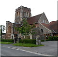
7

St Edyth?s Church, Sea Mills
Also shown at http://www.geograph.org.uk/search.php?i=48106647 , and seen across Riverleaze, which carries the Community Forest Path.
Image: © Derek Harper
Taken: 29 Mar 2014
0.04 miles
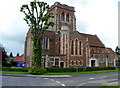
8
St Edyth?s Church, Sea Mills, Bristol viewed from the west
Looking across Avonleaze. St Edyth’s Church is a part of the Diocese of Bristol, Church of England.
Its foundation stone was laid in 1926. The church was consecrated in 1928.
http://www.geograph.org.uk/photo/3029856 to another view.
Image: © Jaggery
Taken: 23 Jun 2012
0.04 miles
9
St Edyth?s Church, Sea Mills, Bristol
Located in Avonleaze, adjacent to The Pentagon, Sea Mills, St Edyth’s Church is a part of the Diocese of Bristol, Church of England. Its foundation stone was laid in 1926. The church was consecrated in 1928.
http://www.geograph.org.uk/photo/3029866 to another view.
Image: © Jaggery
Taken: 23 Jun 2012
0.04 miles
10
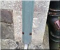
Ordnance Survey Cut Mark
This mostly hidden OS cut mark can be found on the NE face of St Edyth's Church. It marks a point 25.329m above mean sea level.
Image: © Adrian Dust
Taken: 8 Oct 2021
0.05 miles