IMAGES TAKEN NEAR TO
Failand Walk, BRISTOL, BS9 2EU
Introduction
This page details the photographs taken nearby to Failand Walk, BS9 2EU by members of the Geograph project.
The Geograph project started in 2005 with the aim of publishing, organising and preserving representative images for every square kilometre of Great Britain, Ireland and the Isle of Man.

There are currently over 7.5m images from over14,400 individuals and you can help contribute to the project by visiting https://www.geograph.org.uk
Image Map
Images are licensed for reuse under creativecommons.org/licenses/by-sa/2.0
Notes
- Clicking on the map will re-center to the selected point.
- The higher the marker number, the further away the image location is from the centre of the postcode.
Image Listing (74 Images Found)
Images are licensed for reuse under creativecommons.org/licenses/by-sa/2.0
Image
Details
Distance
1
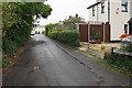
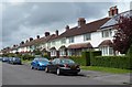
Failand Walk
A narrow residential cul-de-sac.
Image: © Bill Boaden
Taken: 27 Sep 2017
0.02 miles
2
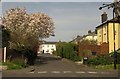
Failand Walk, Sea Mills
Seen from Failand Crescent across Brookleaze. Failand Walk is a cul-de-sac, but in front of the arch at the end, footpath signs point to either side along footpath BCC/76/10.
Image: © Derek Harper
Taken: 29 Mar 2014
0.04 miles
3
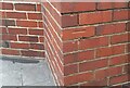
Ordnance Survey Cut Mark
This OS cut mark can be found on No18 St Edyths Road. It marks a point 28.670m above mean sea level.
Image: © Adrian Dust
Taken: 8 Oct 2021
0.05 miles
4
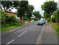
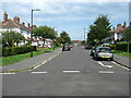
Tree-lined Meadway, Sea Mills, Bristol
Meadway climbs away from Shirehampton Road (B4054).
Image: © Jaggery
Taken: 23 Jun 2012
0.06 miles
5
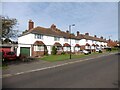
St Edyth's Road houses, Sea Mills, Bristol
Viewed from the Shirehampton Road end.
Image: © Jaggery
Taken: 23 Jun 2012
0.07 miles
6
St Edyth's Road, Sea Mills, Bristol
A residential street in Sea Mills, named after the church which is directly behind the camera.
Image: © David Purchase
Taken: 8 Sep 2021
0.07 miles
8
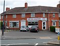
Exquisine, Sea Mills, Bristol
Takeaway (Chinese cuisine and fish & chips), 130 Shirehampton Road.
Image: © Jaggery
Taken: 23 Jun 2012
0.09 miles
9
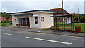
Cafe On The Square, Sea Mills, Bristol
Occupying converted former public conveniences on The Square, Shirehampton Road.
Cafe on the Square is a project from Sea Mills Community Initiatives, a charity set up by the churches in Sea Mills. The cafe is staffed by churchgoers and also by people from the wider local community.
Image: © Jaggery
Taken: 23 Jun 2012
0.09 miles
10
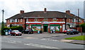
Jones Convenience Stores, Sea Mills, Bristol
Located at 125-127 Shirehampton Road. Formerly a Spar store.
Image: © Jaggery
Taken: 23 Jun 2012
0.09 miles