IMAGES TAKEN NEAR TO
Shirehampton Road, BRISTOL, BS9 2DX
Introduction
This page details the photographs taken nearby to Shirehampton Road, BS9 2DX by members of the Geograph project.
The Geograph project started in 2005 with the aim of publishing, organising and preserving representative images for every square kilometre of Great Britain, Ireland and the Isle of Man.

There are currently over 7.5m images from over14,400 individuals and you can help contribute to the project by visiting https://www.geograph.org.uk
Image Map
Images are licensed for reuse under creativecommons.org/licenses/by-sa/2.0
Notes
- Clicking on the map will re-center to the selected point.
- The higher the marker number, the further away the image location is from the centre of the postcode.
Image Listing (46 Images Found)
Images are licensed for reuse under creativecommons.org/licenses/by-sa/2.0
Image
Details
Distance
1
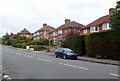
Shirehampton Road houses, Sea Mills, Bristol
Viewed from the corner of Meadway. http://www.geograph.org.uk/photo/3029440
Image: © Jaggery
Taken: 23 Jun 2012
0.05 miles
2
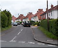
SE side of The Crescent, Sea Mills, Bristol
The Crescent is a semicircular road on the north side Shirehampton Road. The two arms of The Crescent join Shirehampton Road about 300 metres apart.
Image: © Jaggery
Taken: 23 Jun 2012
0.05 miles
3
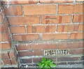
Ordnance Survey Cut Mark
This OS cut mark can be found on No130 Shirehampton Road. It marks a point 28.761m above mean sea level.
Image: © Adrian Dust
Taken: 8 Oct 2021
0.07 miles
4
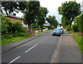
Tree-lined Meadway, Sea Mills, Bristol
Meadway climbs away from Shirehampton Road (B4054).
Image: © Jaggery
Taken: 23 Jun 2012
0.08 miles
5
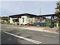
Cafe and bus stop on Shirehampton Road
Image: © Roger Cornfoot
Taken: 7 Oct 2020
0.10 miles
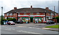
6
Exquisine, Sea Mills, Bristol
Takeaway (Chinese cuisine and fish & chips), 130 Shirehampton Road.
Image: © Jaggery
Taken: 23 Jun 2012
0.11 miles
7
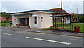
Cafe On The Square, Sea Mills, Bristol
Occupying converted former public conveniences on The Square, Shirehampton Road.
Cafe on the Square is a project from Sea Mills Community Initiatives, a charity set up by the churches in Sea Mills. The cafe is staffed by churchgoers and also by people from the wider local community.
Image: © Jaggery
Taken: 23 Jun 2012
0.11 miles
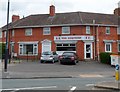
8
Jones Convenience Stores, Sea Mills, Bristol
Located at 125-127 Shirehampton Road. Formerly a Spar store.
Image: © Jaggery
Taken: 23 Jun 2012
0.11 miles
9
Sea Mills Methodist Church
Contemporary with the surrounding inter-war 'garden suburb', this substantial church was built in an era when the provision of facilities for worship were considered an essential element of any housing development - well before pubs and even shops.
Image: © Stephen McKay
Taken: 10 Nov 2010
0.12 miles
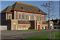
10
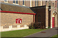
Sea Mills Methodist Church
Showing detail of this large church on Shirehampton Road; see Image for a wider view.
Image: © Stephen McKay
Taken: 10 Nov 2010
0.12 miles