IMAGES TAKEN NEAR TO
Queens Gate, BRISTOL, BS9 1TZ
Introduction
This page details the photographs taken nearby to Queens Gate, BS9 1TZ by members of the Geograph project.
The Geograph project started in 2005 with the aim of publishing, organising and preserving representative images for every square kilometre of Great Britain, Ireland and the Isle of Man.

There are currently over 7.5m images from over14,400 individuals and you can help contribute to the project by visiting https://www.geograph.org.uk
Image Map
Images are licensed for reuse under creativecommons.org/licenses/by-sa/2.0
Notes
- Clicking on the map will re-center to the selected point.
- The higher the marker number, the further away the image location is from the centre of the postcode.
Image Listing (29 Images Found)
Images are licensed for reuse under creativecommons.org/licenses/by-sa/2.0
Image
Details
Distance
1
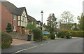
Queens Gate, Bristol
Looking the other way from Image] as the cul-de-sac embarks on a labyrinthine course with several side turnings.
Image: © Derek Harper
Taken: 20 Oct 2022
0.04 miles
2
Queens Gate, Bristol
Traffic calming near the junction with the B4054 (background).
Image: © Derek Harper
Taken: 20 Oct 2022
0.07 miles
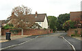
3
One of many imposing houses on Druid Stoke Avenue
Image: © Roger Cornfoot
Taken: 7 Oct 2020
0.09 miles
4

Detached houses on Druid Stoke Avenue
For once, a section of street, missed by Google Maps!
Image: © Roger Cornfoot
Taken: 7 Oct 2020
0.09 miles
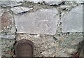
5
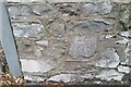
Ordnance Survey Cut Mark
This OS cut mark can be found on the wall at the entrance to the Sub-Station on Shirehampton Road. It marks a point 38.359m above mean sea level.
Image: © Adrian Dust
Taken: 8 Oct 2021
0.11 miles
6
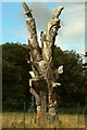
Carved dead tree
Beside Stoke Lodge Playing Fields. The remains of a cedar tree, carved by Andy O'Neill. An owl, snail and butterfly are among the wildlife depicted on this side.
Image: © Derek Harper
Taken: 10 Sep 2022
0.13 miles
7
Ordnance Survey Cut Mark
This OS cut mark can be found on the wall NE side of Shirehampton Road. It marks a point 31.279m above mean sea level.
Image: © Adrian Dust
Taken: 8 Oct 2021
0.13 miles
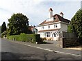
8
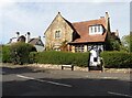
'The Cottage', Stoke Bishop
Grade 2 listed, in Picturesque Gothic Revival style.
Image: © Roger Cornfoot
Taken: 7 Oct 2020
0.15 miles
9
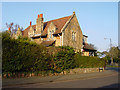
Druid Stoke Avenue, Stoke Bishop
House on the junction of Druid Stoke Avenue and Druid Hill. A Grade II listed building dating from 1860.
Image: © Linda Bailey
Taken: 5 Feb 2006
0.15 miles
10
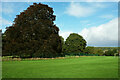
Trees by Stoke Lodge Playing Fields
Behind a controversial fence surrounding the playing fields.
Image: © Derek Harper
Taken: 15 Oct 2022
0.16 miles