IMAGES TAKEN NEAR TO
Roman Way, BRISTOL, BS9 1SQ
Introduction
This page details the photographs taken nearby to Roman Way, BS9 1SQ by members of the Geograph project.
The Geograph project started in 2005 with the aim of publishing, organising and preserving representative images for every square kilometre of Great Britain, Ireland and the Isle of Man.

There are currently over 7.5m images from over14,400 individuals and you can help contribute to the project by visiting https://www.geograph.org.uk
Image Map
Images are licensed for reuse under creativecommons.org/licenses/by-sa/2.0
Notes
- Clicking on the map will re-center to the selected point.
- The higher the marker number, the further away the image location is from the centre of the postcode.
Image Listing (43 Images Found)
Images are licensed for reuse under creativecommons.org/licenses/by-sa/2.0
Image
Details
Distance
1
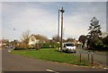
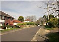
Green, Branscombe Road, Sea Mills
A grass triangle at the junction of Branscombe Road with Roman Way (right).
Image: © Derek Harper
Taken: 29 Mar 2014
0.10 miles
2
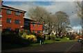
Glenavon Park
A curving road in Sneyd Park. On the left are flats at Glenavon Court.
Image: © Derek Harper
Taken: 28 Dec 2021
0.10 miles
3
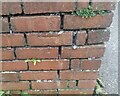
Ordnance Survey Cut Mark
This OS cut mark can be found on the wall of No33 Avon Way. It marks a point 25.829m above mean sea level.
Image: © Adrian Dust
Taken: 8 Oct 2021
0.11 miles
4
Abbeywood Drive, Sea Mills, Bristol
Viewed across Sea Mills Lane. Abbeywood Drive is a cul-de-sac. Its far end is aligned at 90 degrees to the nearer section.
Image: © Jaggery
Taken: 23 Jun 2012
0.11 miles
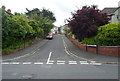
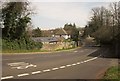
5
Branscombe Road, Sea Mills
The T junction with Avon Way can be seen, with Image] on the far side.
Image: © Derek Harper
Taken: 29 Mar 2014
0.12 miles
6
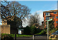
Flats, Glenavon Park
Westonian Court (left) and Glenavon Court, seen from the path that leads down to Old Sneed Park Nature reserve, as the signpost aays.
Image: © Derek Harper
Taken: 28 Dec 2021
0.12 miles
7
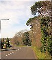
Avon Way, Bristol
The road, followed by the Community Forest Path, drops towards the Trym valley.
Image: © Derek Harper
Taken: 29 Mar 2014
0.13 miles
8
Avon Way, Bristol
The Community Forest Path runs alongside this stretch of the road, but is about to fork off to the right by the trees.
Image: © Derek Harper
Taken: 29 Mar 2014
0.13 miles
10
Path to Old Sneed Park
Leading into the nature reserve from Glenavon Park.
Image: © Derek Harper
Taken: 28 Dec 2021
0.15 miles