IMAGES TAKEN NEAR TO
Pine Ridge Close, BRISTOL, BS9 1RR
Introduction
This page details the photographs taken nearby to Pine Ridge Close, BS9 1RR by members of the Geograph project.
The Geograph project started in 2005 with the aim of publishing, organising and preserving representative images for every square kilometre of Great Britain, Ireland and the Isle of Man.

There are currently over 7.5m images from over14,400 individuals and you can help contribute to the project by visiting https://www.geograph.org.uk
Image Map
Images are licensed for reuse under creativecommons.org/licenses/by-sa/2.0
Notes
- Clicking on the map will re-center to the selected point.
- The higher the marker number, the further away the image location is from the centre of the postcode.
Image Listing (65 Images Found)
Images are licensed for reuse under creativecommons.org/licenses/by-sa/2.0
Image
Details
Distance
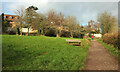
1
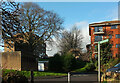
Flats, Glenavon Park
Westonian Court (left) and Glenavon Court, seen from the path that leads down to Old Sneed Park Nature reserve, as the signpost aays.
Image: © Derek Harper
Taken: 28 Dec 2021
0.06 miles
2
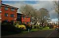
Glenavon Park
A curving road in Sneyd Park. On the left are flats at Glenavon Court.
Image: © Derek Harper
Taken: 28 Dec 2021
0.07 miles
3
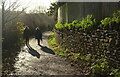
Path to Old Sneed Park
Leading into the nature reserve from Glenavon Park.
Image: © Derek Harper
Taken: 28 Dec 2021
0.10 miles
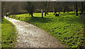
4
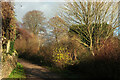
Path from Old Sneed Park
Curving as it climbs steadily from the nature reserve towards Glenavon Park.
Image: © Derek Harper
Taken: 28 Dec 2021
0.11 miles
5
Old Sneed Park Nature Reserve
Looking up the path and hillside shown in Image], with houses on Glenavom Park.
Image: © Derek Harper
Taken: 28 Dec 2021
0.12 miles
6
Old Sneed Park Nature Reserve
The path from Glenavon Park curves down towards the pond. A side path keeps to the contour through the trees on the extreme right.
Image: © Derek Harper
Taken: 28 Dec 2021
0.12 miles
7
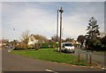
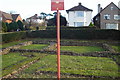
Green, Branscombe Road, Sea Mills
A grass triangle at the junction of Branscombe Road with Roman Way (right).
Image: © Derek Harper
Taken: 29 Mar 2014
0.13 miles
8
Trees at Old Sneed Park Nature Reserve
Looking left from the oath shown in Image], with the pond in shadow to the right. The house is on Bramble Drive.
Image: © Derek Harper
Taken: 28 Dec 2021
0.15 miles
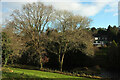
9
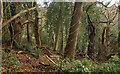
Woodland, Old Sneed Park Nature Reserve
Sweet chestnut and holly are prominent in this part of the wooded valley side at the nature reserve.
Image: © Derek Harper
Taken: 28 Dec 2021
0.15 miles
10
Remains of Roman Dwelling at Portus Abonae (Sea Mills)
Portus Abonae was an ancient Roman Settlement at Sea Mills, where the Roman army would await embarkation for Caerleon, Wales. The photo is apparently of remains of dwellings which formed part of a military fort in Claudian times. It is taken between Roman Way and the Portway, facing due South. Most commuters speeding down the Portway would never know it was there!
Image: © David Dring
Taken: 19 Jan 2006
0.15 miles