IMAGES TAKEN NEAR TO
Mariners Drive, BRISTOL, BS9 1QJ
Introduction
This page details the photographs taken nearby to Mariners Drive, BS9 1QJ by members of the Geograph project.
The Geograph project started in 2005 with the aim of publishing, organising and preserving representative images for every square kilometre of Great Britain, Ireland and the Isle of Man.

There are currently over 7.5m images from over14,400 individuals and you can help contribute to the project by visiting https://www.geograph.org.uk
Image Map
Images are licensed for reuse under creativecommons.org/licenses/by-sa/2.0
Notes
- Clicking on the map will re-center to the selected point.
- The higher the marker number, the further away the image location is from the centre of the postcode.
Image Listing (48 Images Found)
Images are licensed for reuse under creativecommons.org/licenses/by-sa/2.0
Image
Details
Distance
2

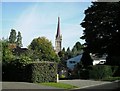
Path running beside the church
Path joining Church Avenue and Mariners Drive.
Image: © Linda Bailey
Taken: 21 Mar 2007
0.02 miles
3
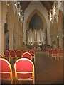
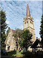
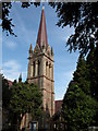
St Mary Magdalene church, Stoke Bishop, Bristol
Image: © David Purchase
Taken: 8 Sep 2021
0.02 miles
4
St Mary Magdalene Church
The parish church of Stoke Bishop seen from Church Road. Dates from 1860.
See Philip Halling's photo for a closer look: http://www.geograph.org.uk/photo/238975
Image: © Thomas Grant
Taken: 5 Oct 2007
0.02 miles
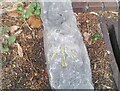
5
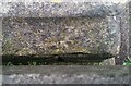
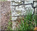
Ordnance Survey Cut Mark
This OS cut mark can just be seen hiding behind a stone block at the north angle of St Mary Magdalene's Church. It marks a point 49.353m above mean sea level.
Image: © Adrian Dust
Taken: 8 Oct 2021
0.03 miles
7
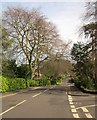
Church Road, Sneyd Park
On the right is the other side of the island seen in Image], so this is the junction with Hazelwood Road.
Image: © Derek Harper
Taken: 29 Mar 2014
0.07 miles
8
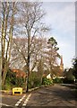
Junction, Sneyd Park
On the left is a triangle formed at the junction of Hazelwood Road with Church road. On the right is the elegant spire of Image
Image: © Derek Harper
Taken: 29 Mar 2014
0.09 miles
9
Ordnance Survey Rivet
This OS rivet can be found on the stone north side of Church Road. It marks a point 200.56ft above mean sea level.
Image: © Adrian Dust
Taken: 8 Oct 2021
0.09 miles
10
Ordnance Survey Cut Mark
This OS cut mark can be found at the junction of Mariners Drive & Druid Road. It marks a point 34.205m above mean sea level.
Image: © Adrian Dust
Taken: 8 Oct 2021
0.10 miles