IMAGES TAKEN NEAR TO
Hazelwood Road, BRISTOL, BS9 1PX
Introduction
This page details the photographs taken nearby to Hazelwood Road, BS9 1PX by members of the Geograph project.
The Geograph project started in 2005 with the aim of publishing, organising and preserving representative images for every square kilometre of Great Britain, Ireland and the Isle of Man.

There are currently over 7.5m images from over14,400 individuals and you can help contribute to the project by visiting https://www.geograph.org.uk
Image Map
Images are licensed for reuse under creativecommons.org/licenses/by-sa/2.0
Notes
- Clicking on the map will re-center to the selected point.
- The higher the marker number, the further away the image location is from the centre of the postcode.
Image Listing (77 Images Found)
Images are licensed for reuse under creativecommons.org/licenses/by-sa/2.0
Image
Details
Distance
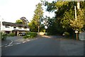
1
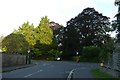
Ivywell Road and crossroads
Looking towards the crossroads with The Avenue and Hazelwood Road.
Image: © DS Pugh
Taken: 22 Aug 2019
0.06 miles
2
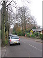
The Avenue, Sneyd Park
A pleasant leafy street of detached houses.
Image: © HelenK
Taken: 20 Nov 2011
0.06 miles
3
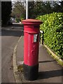
Postbox, Sneyd Park
George V postbox number BS9 379 is at the crossroads of Hazelwood Road (ahead) and The Avenue.
Image: © Derek Harper
Taken: 29 Mar 2014
0.06 miles
4
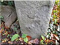
Ordnance Survey Cut Mark
This damaged OS cut mark can be found on gatepost of No14 The Avenue. It marks a point 74.194m above mean sea level.
Image: © Adrian Dust
Taken: 24 Dec 2022
0.06 miles
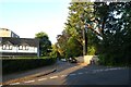
5
Hazelwood Road
Looking towards the junction with Goodeve Road.
Image: © DS Pugh
Taken: 22 Aug 2019
0.07 miles
6
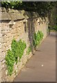
Wall, Goodeve Road, Sneyd Park
Approaching the junction with Hazelwood Road, and with unusual coping and the leaves of campanula.
Image: © Derek Harper
Taken: 29 Mar 2014
0.08 miles
7
Goodeve Road
Looking along Goodeve Road from Hazelwood Road.
Image: © DS Pugh
Taken: 22 Aug 2019
0.09 miles
8
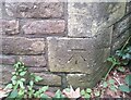
Ordnance Survey Cut Mark
This OS cut mark can be found on the Lodge SW side of Hazelwood Road. It marks a point 71.707m above mean sea level.
Image: © Adrian Dust
Taken: 8 Oct 2021
0.10 miles
9
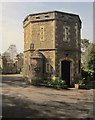
Porter's Lodge, Goodeve Park, Sneyd Park
A curious seven-sided Victorian building beside Hazelwood Road.
Image: © Derek Harper
Taken: 29 Mar 2014
0.10 miles
10
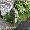
Old Boundary Marker
Estate Boundary Marker on the north side of Ivywell Road opposite Well House Close, Bristol. A Stone is marked at this location on an Ordnance Survey 25-inch map published in 1889. It was perhaps set up when the roads were laid out.
Milestone Society National ID: GL_BRIS14em
Image: © S Kosciow
Taken: 20 Aug 2020
0.11 miles