IMAGES TAKEN NEAR TO
Sea Walls Road, BRISTOL, BS9 1PH
Introduction
This page details the photographs taken nearby to Sea Walls Road, BS9 1PH by members of the Geograph project.
The Geograph project started in 2005 with the aim of publishing, organising and preserving representative images for every square kilometre of Great Britain, Ireland and the Isle of Man.

There are currently over 7.5m images from over14,400 individuals and you can help contribute to the project by visiting https://www.geograph.org.uk
Image Map
Images are licensed for reuse under creativecommons.org/licenses/by-sa/2.0
Notes
- Clicking on the map will re-center to the selected point.
- The higher the marker number, the further away the image location is from the centre of the postcode.
Image Listing (88 Images Found)
Images are licensed for reuse under creativecommons.org/licenses/by-sa/2.0
Image
Details
Distance
1

Avon Grove. Sneyd Park
Image: © Derek Harper
Taken: 29 Mar 2014
0.02 miles
2

Postbox, Sneyd Park
A look at the business side of the George VI box number BS9 532 seen in Image], with Seawalls Road crossing into Image behind.
Image: © Derek Harper
Taken: 29 Mar 2014
0.03 miles
3

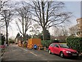
Junction, Sneyd Park
In the foreground is George VI postbox BS9 532, and a sign warning of the roadworks seen in Image In the background, Seawalls Road meets Goodeve Road (right).
Image: © Derek Harper
Taken: 29 Mar 2014
0.04 miles
4
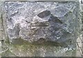
Ordnance Survey Cut Mark
This OS cut mark can be found on the gatepost of Greystone Lodge, Knoll Hill. It marks a point 76.551m above mean sea level.
Image: © Adrian Dust
Taken: 8 Oct 2021
0.04 miles
5
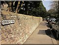
Goodeve Road, Sneyd Park
From the junction shown in Image
Image: © Derek Harper
Taken: 29 Mar 2014
0.05 miles
6
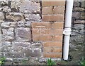
Ordnance Survey Cut Mark
This OS cut mark can be found on Avon Grove Lodge, Seawalls. It marks a point 74.963m above mean sea level.
Image: © Adrian Dust
Taken: 8 Oct 2021
0.05 miles
7

Roadworks, Sneyd Park
The junction of Seawalls Road with The Avenue (right).
Image: © Derek Harper
Taken: 29 Mar 2014
0.06 miles
8
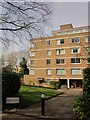
Block of flats, Sneyd Park
Chartley, built in the 1970s, also appears in Image
Image: © Derek Harper
Taken: 29 Mar 2014
0.06 miles
9
The Avenue, Sneyd Park
Roadworks as The Avenue approaches the junction with Seawalls Road.
Image: © Derek Harper
Taken: 29 Mar 2014
0.06 miles
10
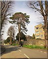
Knoll Hill, Sneyd Park
From the junction with Goodeve Road, shown in Image
Image: © Derek Harper
Taken: 29 Mar 2014
0.06 miles