IMAGES TAKEN NEAR TO
Downleaze, BRISTOL, BS9 1NB
Introduction
This page details the photographs taken nearby to Downleaze, BS9 1NB by members of the Geograph project.
The Geograph project started in 2005 with the aim of publishing, organising and preserving representative images for every square kilometre of Great Britain, Ireland and the Isle of Man.

There are currently over 7.5m images from over14,400 individuals and you can help contribute to the project by visiting https://www.geograph.org.uk
Image Map
Images are licensed for reuse under creativecommons.org/licenses/by-sa/2.0
Notes
- Clicking on the map will re-center to the selected point.
- The higher the marker number, the further away the image location is from the centre of the postcode.
Image Listing (90 Images Found)
Images are licensed for reuse under creativecommons.org/licenses/by-sa/2.0
Image
Details
Distance
1

Bristol : Houses on Downleaze
Houses on Downleaze which overlooks Clifton Down.
Image: © Lewis Clarke
Taken: 19 Jul 2015
0.02 miles
2
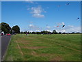
Durdham Down - BS9
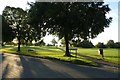
A section of Downleaze (road name) crossing Durdham Down. This is part of a circular route that passes near to the Sea Walls view point - overlooking the Avon Gorge - but that is heading here towards its junction with Stoke Road. Individuals interested in 'things ancients' often seek out some grass covered ridges that can be found intersecting this part of Durdham Down from left to right. These are the buried remains of a Roman road that ran between Portus Abonae (Sea Mills) and Aqua Sulis (Bath). This ancient road (c.50 AD) passes to the north of Bristol, a city that did not exist then.
Image: © David Hallam-Jones
Taken: 31 Jul 2012
0.04 miles
3
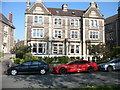
Avonview, Downleaze
Originally two very large semi-detached houses overlooking the Downs, they were combined into one many years ago and now comprise ten flats. The developers adopted the name 'Avonview', quite unsuitable because the one thing you can't see, even from the top floor, is the River Avon - it flows in a gorge about 80 metres deep!
Image: © David Purchase
Taken: 26 Apr 2020
0.04 miles
4
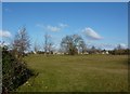
Houses at Stoke Bishop, Bristol
From Durdham Down
Image: © Peter Barr
Taken: 10 Feb 2010
0.04 miles
5
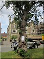
Horse chestnut, Downleaze, Bristol
The future looks bleak for this tree on the edge of the downs; the notice upon it says "canker and decay within trunk". Across Downleaze are a pair of the grand semis that line the edge of the downs here.
Image: © Derek Harper
Taken: 25 Jun 2015
0.04 miles
6
Across Rockleaze
Looking onto Clifton Down with a path leading to Whiteladies Road.
Image: © DS Pugh
Taken: 22 Aug 2019
0.04 miles
7
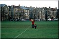
Houses overlooking the Bristol Downs - Looking North
Image: © David Dring
Taken: Unknown
0.04 miles
8
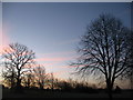
The Moon and Venus (2)
24 hours after Image], Venus is now to the right of, and above the Moon. Venus has not moved much relative to the stars, but the Moon certainly has. (You may need to magnify this photo to see Venus clearly.)
The subject grid reference is, as before, a tree on Durdham Down. No more such photos, I promise!
Image: © David Purchase
Taken: 2 Jan 2019
0.05 miles
9
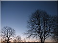
The Moon and Venus (1)
At 7.36 a.m. on New Year's Day, the waning crescent Moon and the planet Venus (below and to the left) were a fine sight. An occultation looked possible, but it was not to be. (New Moon was five days later.)
The subject grid reference is, of course, the tree on Durdham Down!
Image: © David Purchase
Taken: 1 Jan 2019
0.05 miles
