IMAGES TAKEN NEAR TO
Stoke Hill, BRISTOL, BS9 1JR
Introduction
This page details the photographs taken nearby to Stoke Hill, BS9 1JR by members of the Geograph project.
The Geograph project started in 2005 with the aim of publishing, organising and preserving representative images for every square kilometre of Great Britain, Ireland and the Isle of Man.

There are currently over 7.5m images from over14,400 individuals and you can help contribute to the project by visiting https://www.geograph.org.uk
Image Map
Images are licensed for reuse under creativecommons.org/licenses/by-sa/2.0
Notes
- Clicking on the map will re-center to the selected point.
- The higher the marker number, the further away the image location is from the centre of the postcode.
Image Listing (49 Images Found)
Images are licensed for reuse under creativecommons.org/licenses/by-sa/2.0
Image
Details
Distance
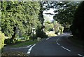
1
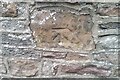
Ordnance Survey Cut Mark
This damaged OS cut mark can be found on the wall NE side of Stoke Hill. It marks a point 68.373m above mean sea level.
Image: © Adrian Dust
Taken: 8 Oct 2021
0.03 miles
2
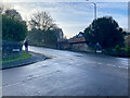
A road sign in Bristol
There is an OS benchmark Image behind the street sign for Stoke Park Road at the junction with Stoke Hill.
Image: © Neville Goodman
Taken: 10 Jan 2021
0.04 miles
3
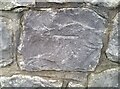
Ordnance Survey Cut Mark
This OS cut mark can be found on the wall at the junction of Stoke Hill & Stoke Park Road. It marks a point 57.845m above mean sea level.
Image: © Adrian Dust
Taken: 8 Oct 2021
0.04 miles
4
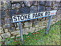
Benchmark behind a street sign
The OS description is WALL SE SIDE STOKE PARK RD JUNC STOKE HILL Image The mark is listed as 0.5 m above ground level but is clearly higher than that.
Image: © Neville Goodman
Taken: 10 Jan 2021
0.04 miles
5
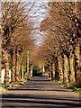
Church Avenue
Looking along Church Avenue in the spring sunshine.
Image: © Linda Bailey
Taken: 21 Mar 2007
0.05 miles
6
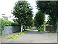
Church Road
Looking along Church Road in Clifton.
Image: © DS Pugh
Taken: 22 Aug 2019
0.05 miles
7
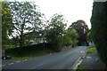
Church Avenue, Stoke Bishop, Bristol
This is a private road. I am looking away from the church towards Stoke Hill.
Image: © David Purchase
Taken: 8 Sep 2021
0.06 miles
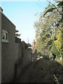
8
Footpath to Sea Mills
Looking along a footpath from Church Road.
Image: © DS Pugh
Taken: 22 Aug 2019
0.06 miles
10
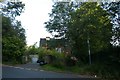
Pitch and Pay Lane
Roman Road running down to the Claudian settlement at Sea Mills - a geograph of which is here http://www.geograph.org.uk/photo/108763 . The spire of St Mary Magdalene is in the distance.
Image: © Thomas Grant
Taken: 5 Oct 2007
0.08 miles