IMAGES TAKEN NEAR TO
Cranleigh Gardens, BRISTOL, BS9 1HD
Introduction
This page details the photographs taken nearby to Cranleigh Gardens, BS9 1HD by members of the Geograph project.
The Geograph project started in 2005 with the aim of publishing, organising and preserving representative images for every square kilometre of Great Britain, Ireland and the Isle of Man.

There are currently over 7.5m images from over14,400 individuals and you can help contribute to the project by visiting https://www.geograph.org.uk
Image Map
Images are licensed for reuse under creativecommons.org/licenses/by-sa/2.0
Notes
- Clicking on the map will re-center to the selected point.
- The higher the marker number, the further away the image location is from the centre of the postcode.
Image Listing (25 Images Found)
Images are licensed for reuse under creativecommons.org/licenses/by-sa/2.0
Image
Details
Distance
1
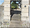
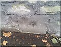
A double benchmark
There is a benchmark in the OS database, description P ENT NO44 STOKE HILL. It is on the stone next to bottom on the right-hand gatepost. On closer inspection Image, it is a double mark, and I'm not sure which one is the database mark.
Image: © Neville Goodman
Taken: 11 Jun 2017
0.08 miles
2
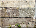
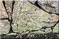
Double benchmark detail
This is a close-up of the bottom of the gatepost in Image
Image: © Neville Goodman
Taken: 11 Jun 2017
0.08 miles
4
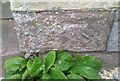
Ordnance Survey Cut Mark
This OS cut mark can be found on the gatepost of No44 Stoke Hill. It marks a point 33.641m above mean sea level.
Image: © Adrian Dust
Taken: 8 Oct 2021
0.08 miles
5
Ordnance Survey Cut Mark
This OS cut mark can be found on the wall SW side of Stoke Hill. It marks a point 49.173m above mean sea level.
Image: © Adrian Dust
Taken: 8 Oct 2021
0.12 miles
6
Benchmark on a suburban street
The OS description is NBM WALL NE SIDE STOKE HILL OPP MURDENE: see Image
Image: © Neville Goodman
Taken: 10 Jan 2021
0.13 miles
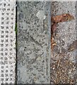
7
Benchmark on a kerbstone
The OS description is KERB SE SIDE STOKE PARK RD Image I can't give a View Direction because the camera was pointing straight down, although I was facing south east.
Image: © Neville Goodman
Taken: 10 Jan 2021
0.13 miles
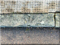
8
Ordnance Survey Rivet
This damaged OS rivet can be found on the kerb stone SE side of Stoke Park Road. It marks a point 53.922m above mean sea level.
Image: © Adrian Dust
Taken: 8 Oct 2021
0.13 miles
9
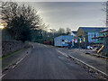
A street in Sneyd Park
There is an OS benchmark low down on the wall on the left of Hollymead Lane looking south. The OS description says that it is opposite Murdene Image Murdene is no more: there is a building site (Jan 2021), although the resulting new build may still be called Murdene, I suppose. The description also says this is Stoke Hill: it may have been, but it is now Hollymead Lane.
Image: © Neville Goodman
Taken: 10 Jan 2021
0.14 miles
10
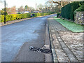
A suburban street in Bristol
Stoke Park Road on a cold but sunny Sunday morning during lockdown in January 2021. Lots of people were out taking exercise. There is an OS benchmark Image on the kerbstone just before the grid.
Image: © Neville Goodman
Taken: 10 Jan 2021
0.14 miles