IMAGES TAKEN NEAR TO
Abbey Gate, BRISTOL, BS9 1FJ
Introduction
This page details the photographs taken nearby to Abbey Gate, BS9 1FJ by members of the Geograph project.
The Geograph project started in 2005 with the aim of publishing, organising and preserving representative images for every square kilometre of Great Britain, Ireland and the Isle of Man.

There are currently over 7.5m images from over14,400 individuals and you can help contribute to the project by visiting https://www.geograph.org.uk
Image Map
Images are licensed for reuse under creativecommons.org/licenses/by-sa/2.0
Notes
- Clicking on the map will re-center to the selected point.
- The higher the marker number, the further away the image location is from the centre of the postcode.
Image Listing (24 Images Found)
Images are licensed for reuse under creativecommons.org/licenses/by-sa/2.0
Image
Details
Distance
1
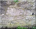
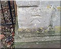
Ordnance Survey Cut Mark
This OS cut mark can be found on the wall south side of Parry's Lane. It marks a point 39.481m above mean sea level.
Image: © Adrian Dust
Taken: 17 Jan 2020
0.07 miles
2
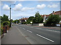
Parry's Lane, Bristol
This road, despite its name, is the B4054 and is an important artery in north-west Bristol, especially as it passes (behind the camera) the major residential area for the university.
Image: © David Purchase
Taken: 18 Jul 2018
0.13 miles
3
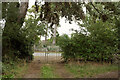
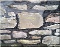
Gates by Stoke Lodge Playing Fields
A path circumnavigates the playing fields, turning right here. Beyond the gates is the B4054 at the junction of Parry's Lane and Cross Elm Lane.
Image: © Derek Harper
Taken: 10 Sep 2022
0.13 miles
4
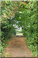
Path, Stoke Lodge Playing Fields
A path circumnavigates the playing fields. Here it runs between them and Parry's Lane.
Image: © Derek Harper
Taken: 10 Sep 2022
0.13 miles
5
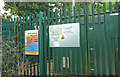
Gas distribution site, Stoke Bishop
One notice reads "please could you refrain from parking under the canopy of trees. These trees have Tree Preservation Orders on them and are protected".
Image: © Derek Harper
Taken: 10 Sep 2022
0.14 miles
6
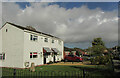
Houses on Cross Elms Lane
Terraced houses in Stoke Bishop.
Image: © Derek Harper
Taken: 15 Oct 2022
0.14 miles
7
Ordnance Survey Cut Mark
This OS cut mark can be found on the wall SE side of Parry's Lane. It marks a point 41.108m above mean sea level.
Image: © Adrian Dust
Taken: 17 Jan 2020
0.14 miles
8
Ordnance Survey Cut Mark
This OS cut mark can be found on the gatepost north side of Holly Bush Lane. It marks a point 42.194m above mean sea level.
Image: © Adrian Dust
Taken: 17 Jan 2020
0.15 miles
9
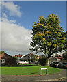
Small green space, Stoke Bishop
At the junction of South Dene (foreground) and Cross Elms Lane.
Image: © Derek Harper
Taken: 15 Oct 2022
0.16 miles
10
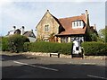
'The Cottage', Stoke Bishop
Grade 2 listed, in Picturesque Gothic Revival style.
Image: © Roger Cornfoot
Taken: 7 Oct 2020
0.18 miles